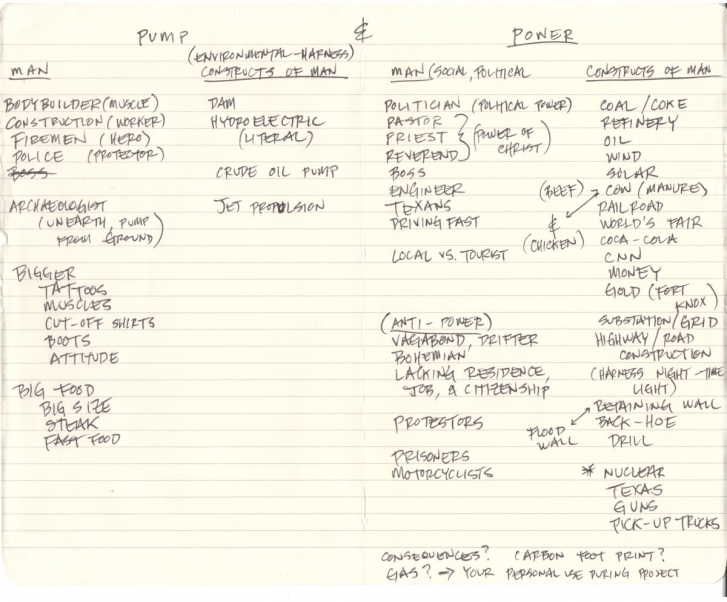
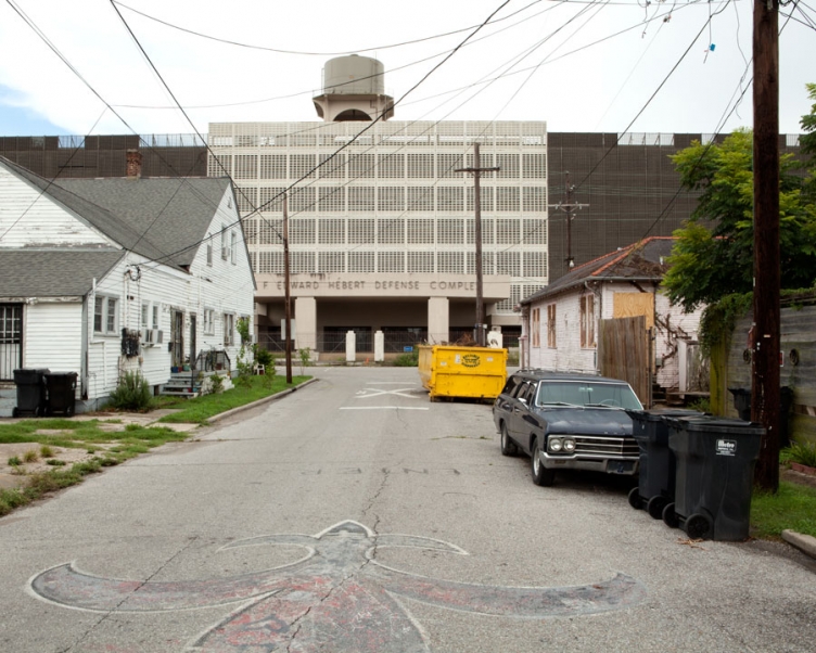
pump and power
2012-14
I use the camera to explore concepts of literal and perceived power. I follow power lines that originate from oil, coal, hydroelectric, nuclear, or solar facilities. Power lines lead me in and out of cities, towns, and sometimes into the homes of strangers. The places I go and the people I meet result in observations and discussions that consider more abstract and intangible concepts of perceived power – social, spiritual, economic, and political. Most Americans are unaware yet dependent upon the electrical grid that feeds their consumption needs. We have become habituated to power lines hanging above streets, criss-crossing terra firma, and floating into our homes. The people of the United States are interconnected, at least regionally, by a grid of low-hanging wires. I am driven to document paths that connect Americans, and discover transient relationships between people and power – literal and perceived.
journal entry
2012
While traveling I kept notes, lists, and thoughts on Pump and Power. I examined the literal and figurative constructs of American Power. I followed power lines across the American midwest, east, and south. The power lines lead me to literal sources of Pump and Power - substations, generating stations, oil, coal, nuclear, hydroelectric, manure, solar, and wind. The power lines additionally lead me into people's lives and homes to examine Perceived Power - social, spiritual, economic, and political.
found object
2012
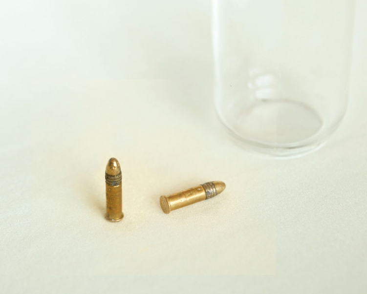
The day before I left Chicago, on the last day of school, I discovered these bullets in the parking lot of the Chicago High School for the Arts where I was a Photography and Digital Media instructor. Before I made a photograph, I found an object that symbolized Power. This was the first of many objects collected for this project.
archival ink jet print
20" x 25"
2012
archival ink jet print
20" x 25"
2012
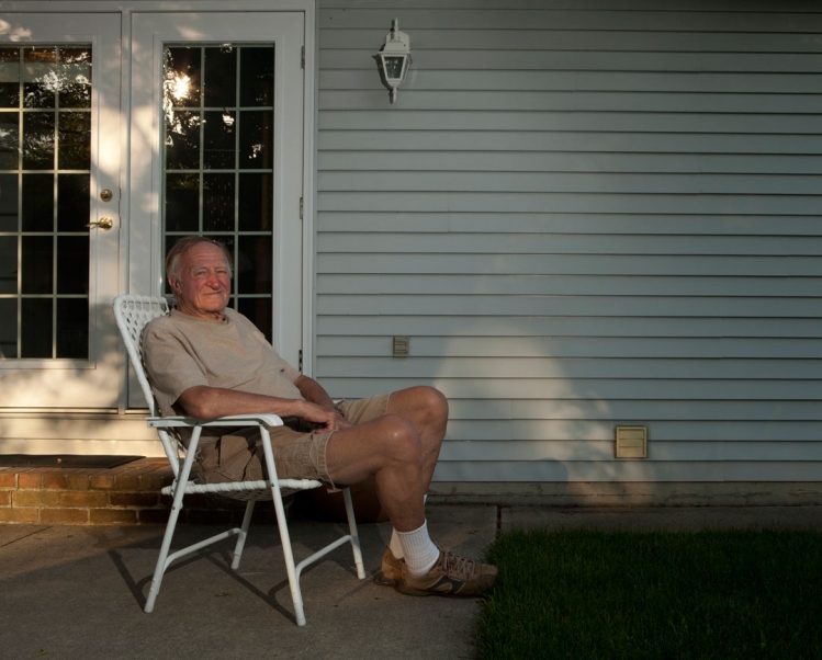
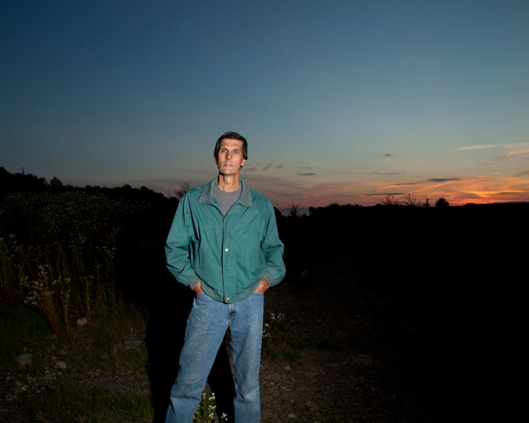
While staying at a friend's cottage on Lake Huron, I met Marco, a retired neighbor. Marco was 84 years old at the time of this image. Although retired, he refuses to be inactive. He was mending a fence when I asked him if he needed assistance. I discovered he worked most of his life at Imperial Oil - only 5 miles from his cottage home.
archival ink jet print
20" x 25"
2012
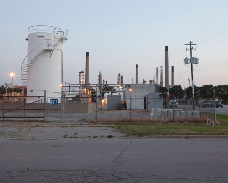
Immediately after making this image, Imperial Oil's security staff and Sarnia police attempted to arrest me. They forced me to sit on the ground while they searched my background for a criminal record. Imperial's Sarnia operation is the most integrated fuels, chemicals manufacturing and petroleum research facility in Canada. The refinery can process about 120,000 barrels of crude oil daily. This crude oil is processed into a wide range of products for heat, light and transportation. The petroleum industry arose in parallel in the U.S. and Canada. Both Sarnia and Oil Creek Valley, Pennsylvania dispute the first successful drilling rig on a well to produce petroleum.
archival ink jet print
20" x 25"
2012
The Sir Adam Beck Generating Station is situated on private land behind the welcome center to Niagara Falls. While tourists snapped pictures in front of barrels and historical landmarks, I examined the falls as a source of industrial and hydroelectric power.
archival ink jet print
20" x 25"
2012
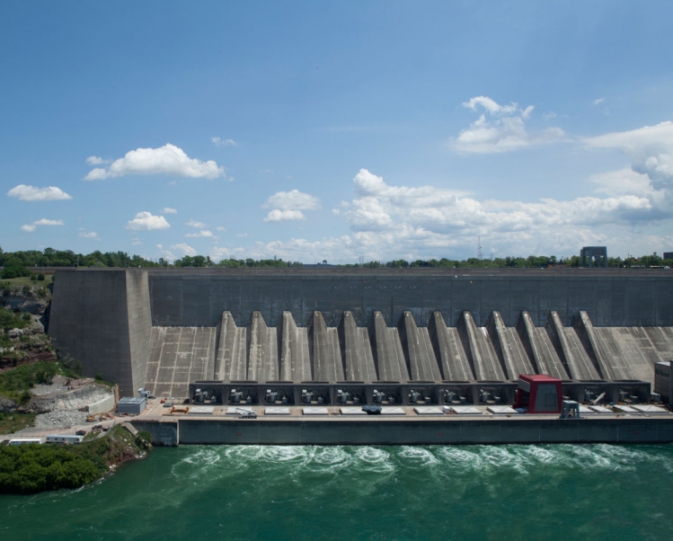
The Robert Moses Niagara Hydroelectric Power Station diverts water from the Niagara River above Niagara Falls and returns the water into the lower portion of the river near Lake Ontario. It utilizes 13 generators at an installed capacity of 2,525 megawatts. It is directly opposite of the Sir Adam Beck Hydroelectric Power Station in Ontario, Canada. It is named after Robert Moses - a mid-20th Century urban planner in New York. A civil lawsuit against the New York Power Authority, Occidental Petroleum, Hooker Chemicals, Bechtel Corporation, and Parsons Brinckerhoff which had dumped hazardous chemicals underground, settled out of court in 1999. Subsequent testing near the Lewiston Reservoir near the project still confirms mercury and organic contamination which restricts the consumption of fish.
archival ink jet print
20" x 25"
2012
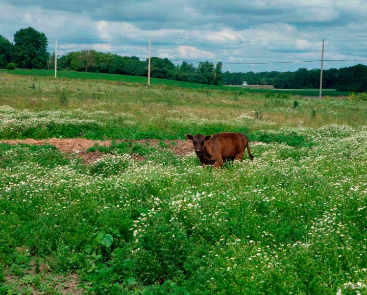
This calf was as interested in me as I was in him. Americans are obsessed with beef, averaging 270 pounds per person per year. The meat culture of America is often viewed as unhealthy, and economically and environmentally irresponsible.
archival ink jet print
20" x 25"
2012
Eighty percent of all manufactured anhydrous ammonia is used as fertilizer. These fertilizers are applied directly to soil to provide nitrogen to plants. Ammonia is also used to manufacture synthetic fibers, plastics, and explosives.
archival ink jet print
20" x 25"
2012

archival ink jet print
20" x 25"
2012
I was obsessed with fire as a youth. I used to steal gasoline from my dad's lawnmower and start fires in the woods behind my childhood home. Although fire is a destructive force, it also has the power to renew.
archival ink jet print
20" x 25"
2012
archival ink jet print
20" x 25"
2012
Audet's Blue Spruce Farm is the first Cow Power farm in Vermont that is a completely renewable energy system. All the waste from the farm is collected and pumped into a biodigester. The methane gas produced from the biodigester is used to power generators that push enough electricity onto the grid for about 300+ homes. Excess heat from methane-powered generator provides hot water to the farm and radiant floor heat in the office and milking parlor. With a Cow Power project, there are no fossil fuels consumed to make energy, therefore, the carbon released from the generators is considered global warming neutral.
archival ink jet print
20" x 25"
2012
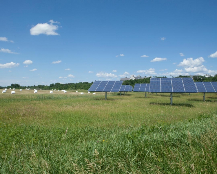
The one-and-a-half acre solar farm installed at Middlebury College has 34 pole-mounted solar arrays that produce an average of 200,000 kilowatt-hours annually. The solar trackers use GPS and wireless technology to follow the sun throughout the day, producing more than 40 percent more energy than fixed solar panels of comparable size.
archival ink jet print
20" x 25"
2012
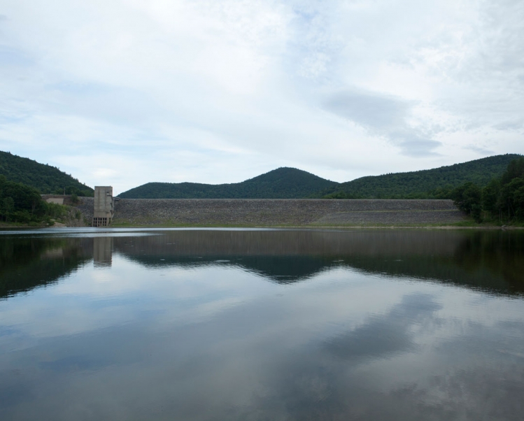
The earthen dam was constructed in 1961 by the United States Army Corps of Engineers with a height of 126 feet and a length of 1700 feet at its crest. It impounds Vermont's West River for flood control and seasonal storm water management. The dam is owned and operated by the Corps of Engineers.
archival ink jet print
20" x 25"
2012
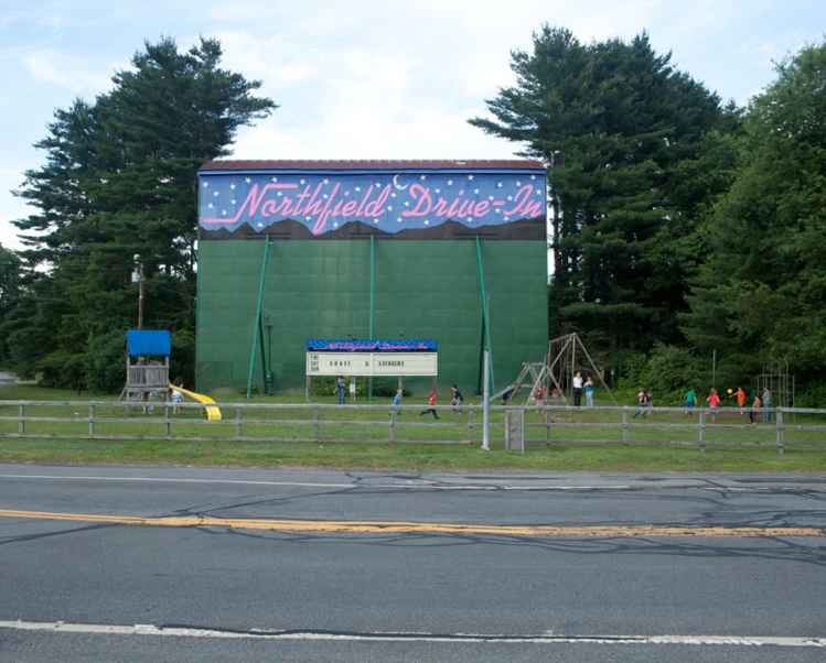
The Northfield Drive-In is the only drive-in theatre that straddles the border between two states - MA and NH. It is one of less than twenty drive-in theatres still remaining in all of New England.
archival ink jet print
20" x 25"
2012
Walking onto the campus of this decommissioned nuclear facility, I was greeted by two men with M16 rifles and one slightly more restrained yet serious man who explained that I could be shot for being on the property. There were no signs or entrance gate - just a small building about 50 feet from a parking lot which looked (to me) to be a "welcome center." This image was taken from across the river with a view of the Independent Spent Fuel Storage Installation - which is the only place, as it was explained to me, to photograph and not be shot.
archival ink jet print
20" x 25"
2012
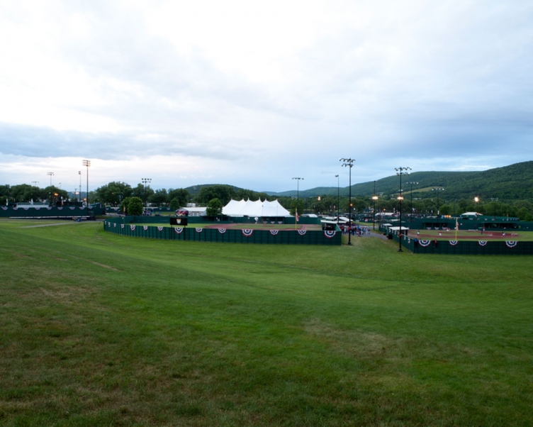
The Village of Cooperstown is home to the National Baseball Hall of Fame and Doubleday Field, the legendary home of baseball where the game began in 1839. Each year the participants of the Cooperstown Dreams Park National Invitational Tournament are inducted into the American Youth Baseball Hall of Fame.
archival ink jet print
20" x 25"
2012
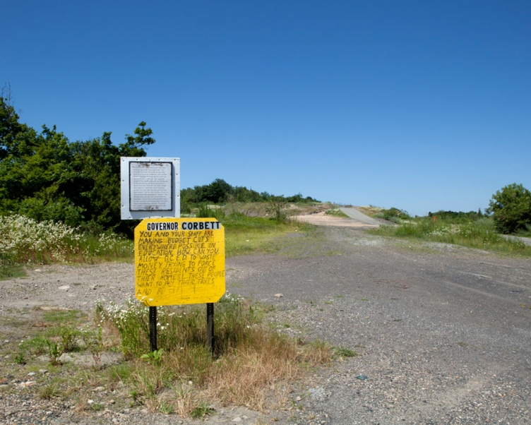
"Governor Corbett. Why must you force these people from their homes to get at the coal underneath. You know the so called “fire” is an excuse. Why were there never any boreholes north of Park Street? Because PA knew the fire wasn’t going into the town back then. Why were the people’s CO2 alarms going off, was it because of the coal ash you poured in the ground instead of the fire? Nice trick, but some people were wise to it. How many of the Centralia people have died after they were forced from their homes? The fire didn’t do that. PA did. Is Pennsylvania that desperate for money? Are Pennsylvania and the local coal dealers that heartless? Only to tear up this beautiful country side and leave another big black hole to be filled in with more toxic coal ash. The whole idea is sick. Leave these people alone, dig somewhere else.”
archival ink jet print
20" x 25"
2012
To clean up the Centralia landfill for Memorial Day in 1962, the Centralia Council hired five members of the volunteer firefighter company to ignite the garbage in the landfill on May 27, 1962. The fire ignited a coal seam underneath the city. The fire continue to burns today at depths of up to 300 feet over an eight-mile stretch of 3,700 acres. At its current rate, it could burn for over 250 more years. This image made in 2012 denotes the 50th anniversary of the fire.
archival ink jet print
20" x 25"
2012
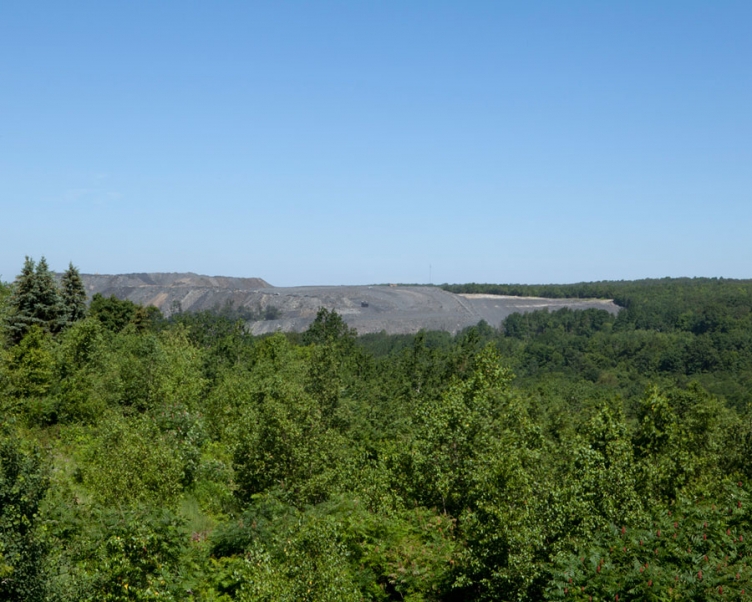
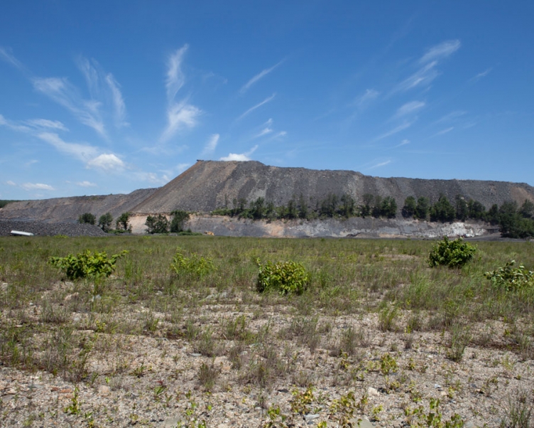
While traditional coal mining extracts coal from underground, an increasingly popular mining method called mountaintop removal mining blasts away chunks of mountains to get at the coal beneath. This method requires fewer workers than others, thus reducing jobs (and the cost of electricity). But there's also no getting around the major health and environmental problems caused by both coal mining and coal burning. To get at the coal, first all the standing trees are removed. They're either burned or used to fill excavated valleys. Then bulldozers come in and plow under any remaining obstacles including houses. Miners then pour a blasting agent called ammonium nitrate/fuel oil (ANFO) into large holes drilled in the ground. When ANFO is detonated residue, silica, coal, and rock dust can burst into the air, where it drifts to communities miles away before settling to a coat of dust.
archival ink jet print
20" x 25"
2012
In 1980 the population of Centralia was 2,761 despite lethal levels of carbon monoxide - byproducts of the fire. In 1984, Congress allocated relocation efforts and most of the residents accepted buyout offers and moved to the nearby communities of Mount Carmel and Ashland. Pictured here is John - a former resident of Centralia whose family moved to Mt. Carmel when he was a boy. Although most of the buildings have been leveled, John regularly hikes the remains of the city and visits the cemeteries of Centralia where his grandparents are buried.
archival ink jet print
20" x 25"
2012
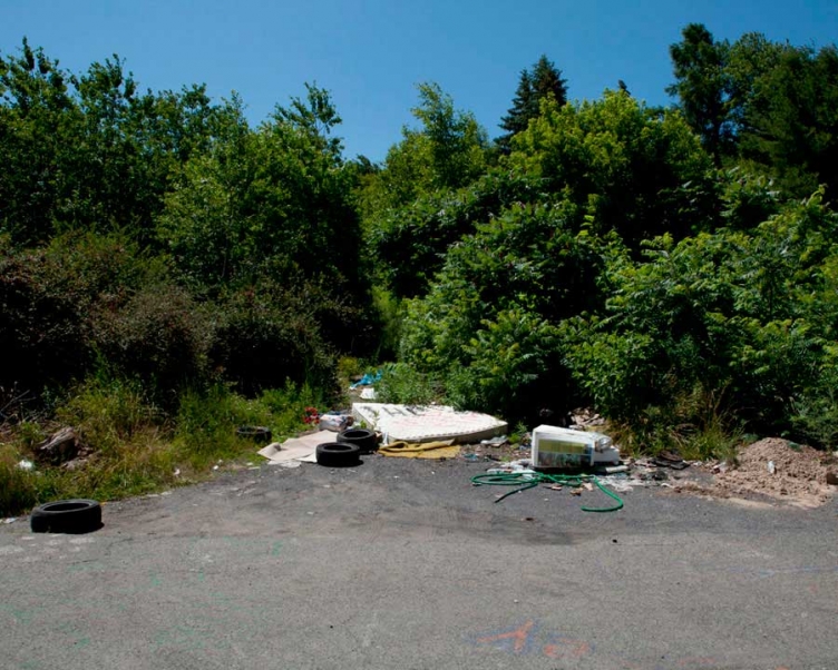
The abandoned streets of Centralia have become a dumping ground for unwanted items. This site showed evidence of a teenage haunt with empty beer cans and graffiti. Ironically enough this abandoned mattress appeared to have a second life as a make-shift lounge.
archival ink jet print
20" x 25"
2012
Despite urgings from Pennsylvania officials, a few Centralia families opted to stay. In 1992, Pennsylvania governor Bob Casey invoked eminent domain on all properties in the borough, condemning all the buildings within. A subsequent legal effort by residents to have the decision reversed failed. In 2002, the U.S. Postal Service revoked Centralia's ZIP code, 17927. In 2009, Governor Ed Rendell began the formal eviction of Centralia residents. In July 2012, the last handful of residents in Centralia lost their appeal of a court decision upholding eminent domain proceedings, and were ordered again to leave. State and local officials reached an agreement with the seven remaining residents on October 29, 2013 allowing them to live out their lives there, after which the rights of their properties will be taken through eminent domain.
archival ink jet print
20" x 25"
2012
archival ink jet print
20" x 25"
2012
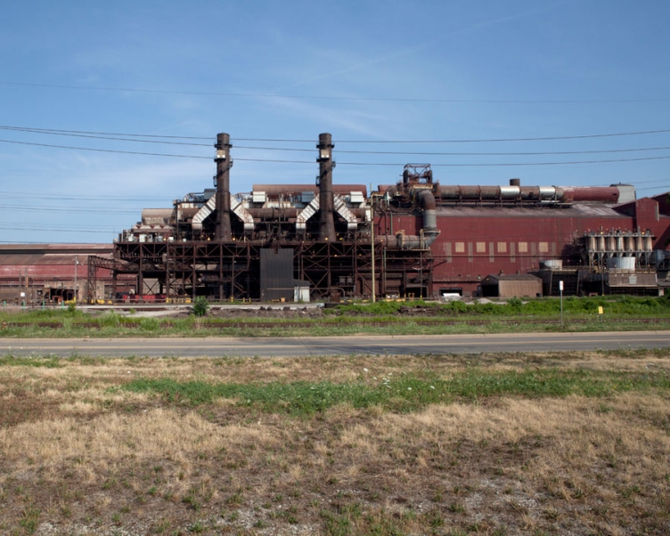
ArcelorMittal Cleveland is recognized as one of the most productive facilities in the world, producing one ton of steel for slightly more than one worker hour. Pictured is one of two blast furnaces which can feed two steelmaking facilities capable of producing 3.8 million tons of raw steel annually. The Cleveland plant covers more than 950 acres of land along the Cuyahoga River. The plant’s buildings total seven million square feet. Products made at this location are hot-rolled, cold-rolled and hot-dipped galvanized sheet and semi-finished. Markets this plant serves include automotive, service centers, converters, plate slabs and tubular applications.
archival ink jet print
20" x 25"
2012
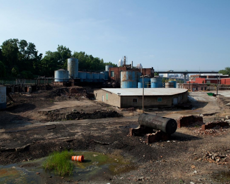
Werner G. Smith is a manufacturer of fatty oils and synthetic esters and processors of vegetable oils and fish oils, blown oils and non ionic emulsifiers.
From a Cleveland Board of Building Standards Public Hearing: "Werner G. Smith, Inc., Owner of the F-2 Factory – Low Hazard (Non-combustibles) Two Story Masonry Property appeals from a NOTICE OF VIOLATION—EXTERIOR MAINTENANCE, dated August 14, 2012; appellant states that they have contacted a number of contractors to do some of the repair work, but they either have given bids or not bothered to inspect and bid. Some of the bid quotes have been excessive, well above what they think is reasonable. Their financial situation is limited. They have been awash in red ink for the past five (5) years due to economic downturn so their finances are very tight. Appellant is asking for an extension to complete the necessary work."
archival ink jet print
20" x 25"
2012
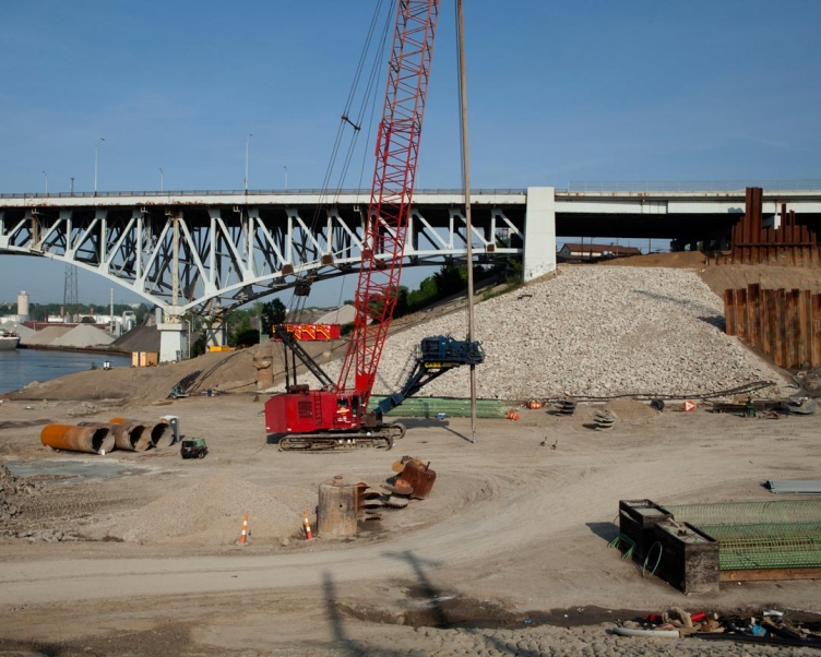
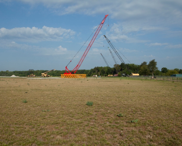
The Innerbelt Bridge, completed in 1959, was a truss arch bridge carrying Interstate 90/Innerbelt Freeway over the Cuyahoga River. In 2008 all commercial truck traffic was banned because it was deemed structurally insufficient. As part of the Innerbelt Freeway rebuild, the bridge is being replaced by the George V. Voinovich Bridges. The new westbound bridge opened and the Innerbelt Bridge was vacated in 2013, and the eastbound bridge, projected to be built in the location of the Innerbelt Bridge, is planned to open in 2016. Pictured is the groundbreaking for the new Voinovich Bridges and the truss arches of the Innerbelt Bridge in the background.
archival ink jet print
20" x 25"
2012
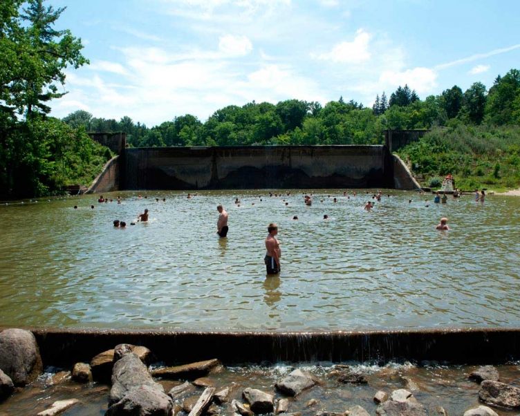
Construction of the dam started in 1926 and was built with the purpose to block water from the Rocky River to hold back enough to fill a 100-acre lake. Today, part of Hinckley Lake is enjoyed by visitors as a sandy swimming area. As I made this image, the future of the boy in the foreground appears to be predicted by his resemblance to the man behind him.
archival ink jet print
20" x 25"
2012
Bridgeport is a village that is part of the Wheeling, West Virginia Metropolitan Statistical Area. The population was 1,831 at the 2010 census. It lies across the Ohio River from Wheeling, West Virginia and is connected by two bridges to Wheeling Island in the Ohio River.
archival ink jet print
20" x 25"
2012
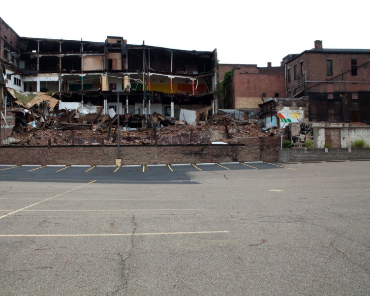
Wheeling is located along the Ohio River in the foothills of the Appalachian Mountains. Traveling through downtown I encountered this partially demolished building. This interior of the building was colorful with 80's paintings and spiral columns. Since World War II, after the closing of industry, Wheeling has been experiencing substantial population loss.
archival ink jet print
20" x 25"
2012
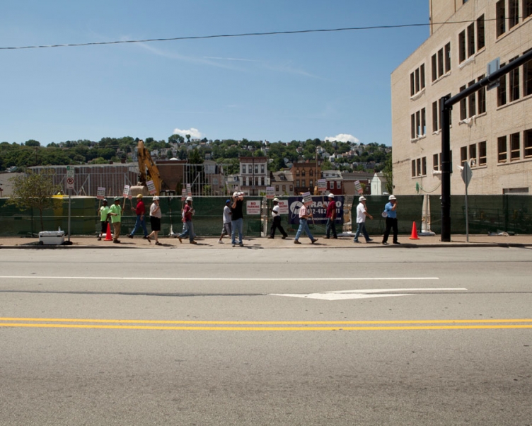
These workers were protesting Franjo Construction Corporation with signs that read "Franjo does not pay area standard wages & benefits." These workers are powerless against corporate wages, but have the Power of a Union behind them. The man in the middle of the image was recording me with video as I made this image. I learned that it is common practice for the Construction company to photograph the identities of the protesting workers.
archival ink jet print
20" x 25"
2012
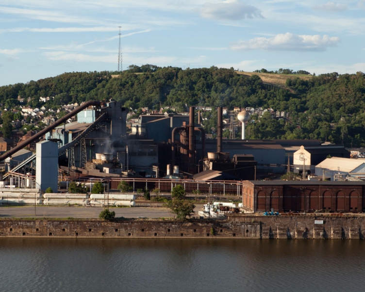
The mill occupies the historic site of Braddock's Field, on the banks of the Monongahela River east of Pittsburgh. On July 9, 1755, in the Battle of the Monongahela, French and Indian forces from Fort Duquesne defeated the expedition of British General Edward Braddock, who himself was mortally wounded. Today, two blast furnaces operate at the Edgar Thomson Steel Works. In 2005, the mill produced 2.8 million tons of steel, equal to 28% of U.S. Steel’s domestic production. The mill employs about 900 persons, some of whom belong to the second or third generations of their families to work in the mill. The site is on the banks of the Monongahela, which provides cost-effective, riverine transportation of coke, iron and finished steel products. My brother John works for U.S. Steel Tublular Operation in Lorain, Ohio.
archival ink jet print
20" x 25"
2012
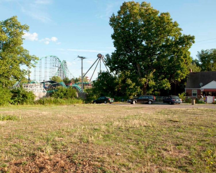
Directly across the Monongahela River from U.S. Steel Braddock is Kennywood Amusement Park. Kennywood was founded in 1898 as a small trolley park by the Monongahela Street Railway Company. Kennywood grown to build roller coasters and other attractions and has survived the Great Depression and growing competition. This image was made from behind Kennywood where it overlooks a neighborhood. The resident who lives directly next to the amusement park claims to enjoy the patron's screams and the machine's metal clanks.
archival ink jet print
20" x 25"
2012
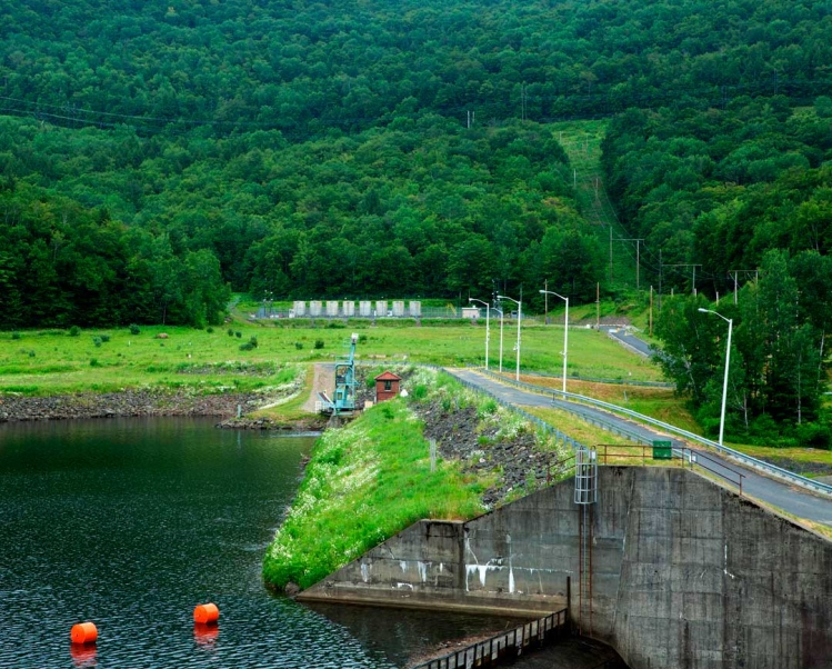
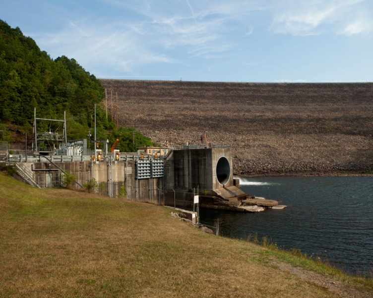
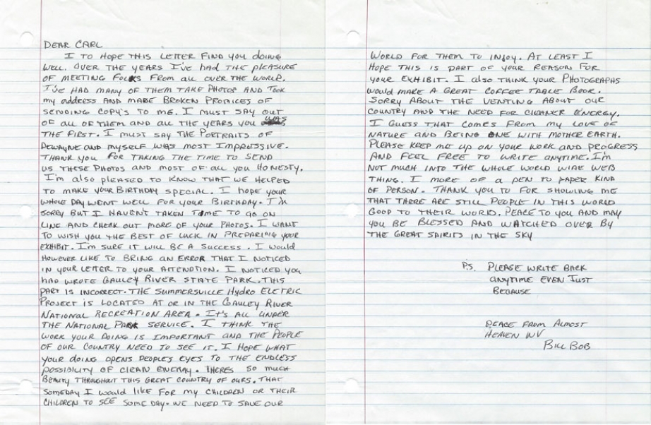
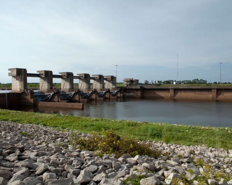
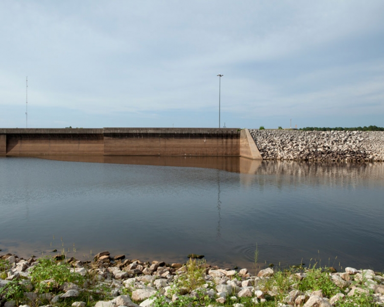
The Summerville Hydro Project generates about 220 million kilowatt-hours annually – enough energy to power 22,000 homes. It avoids the emission of about 221,000 tons of carbon dioxide annually that would be emitted by an equivalent energy from fossil-fueled generation. Summersville Dam was built by the federal government in 1967 and is operated by the Army Corps of Engineers for several purposes: flood control, low flow augmentation, lake recreation, enhancement of fish and wildlife, fishing in the river below the dam, and whitewater rafting on the Gauley River.
archival ink jet print
20" x 25"
2012
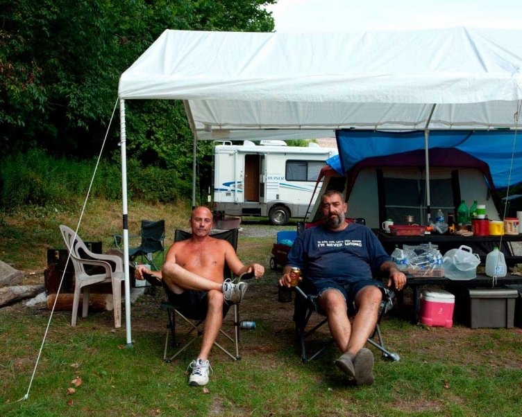
Located just below Summersville Dam, The National Park Service offers free primitive camping at Gauley Tailwaters. I spent the night at the Tailwaters on my birthday. As I was setting up my tent and looking for firewood, Dewanye approached me holding a machete. I had preconceptions of West Virginians and didn't know what to expect. In fact, Dewayne and Billy Bob were incredibly friendly and willing to lend their gear. Dewayne allowed me to use his machete to chop wood for a fire. We spent the night drinking beers and sharing stories. Dewayne and Billy Bob meet annually to spend their summers camping at this site and have invited me back every year since we met.
11" x 8.5"
2012
archival ink jet print
20" x 25"
2012
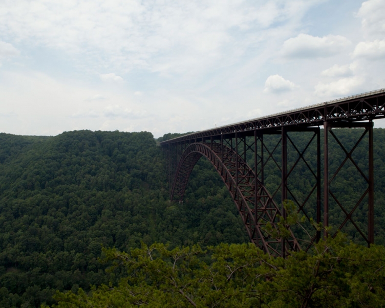
The New River Gorge Bridge is a steel arch bridge 924 m long over the New River Gorge near Fayetteville, West Virginia, in the Appalachian Mountains. With an arch 518 m long, the New River Gorge Bridge was for many years the world's longest steel single-span arch bridge; it is now the fourth longest. The roadway of the New River Gorge Bridge is 267 m above the New River. When it opened in 1977, the New River Gorge Bridge was the highest vehicular bridge in the world and is currently the third highest in the United States. The bridge is crossed by an average of 16,200 motor vehicles per day.
found object
2012
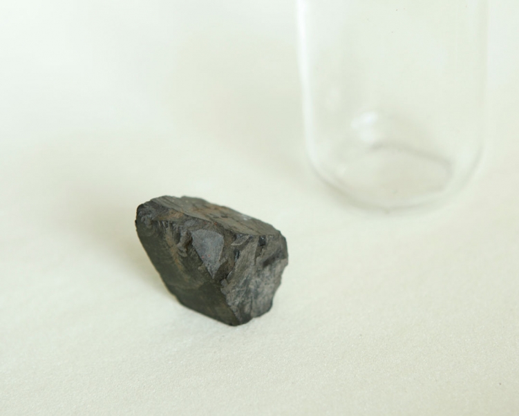
In 1870, England-born entrepreneur John Nuttall saw opportunity in the coal rich New River Gorge. When the Chesapeake & Ohio Railway was completed through the gorge in 1873, Nuttallburg was ready to ship the "smokeless" coal, processed from a mineral seam hundreds of feet above the river corridor and shipped to industrial cities hundreds of miles away. In 1920 Henry Ford, in an effort known as "vertical integration" to gain control of all aspects of production, leased the town's mines to provide coal for his company steel mills. Production ceased in 1958 and Nuttallburg became like so many other riverside communities that rose and fell due to changes in the industry. In 1998 the Nuttall family transferred ownership of Nuttallburg to the National Park Service. I found this piece of coal near an old coke oven.

archival ink jet print
20" x 25"
2012
Coal provides about 40% of the United States' electricity and plays a vital role in the economy of West Virginia. In the 1970's, strip mine legislation opened the possibility for an alternative called mountaintop removal (MTR). It became a popular West Virginia coal mining technique because it's far cheaper than underground mining and requires much less manpower to perform. The Sierra Club calls mountaintop removal mining, "Quite possibly the worst environmental assault yet." The Appalachian mountains are among the oldest in the world. They're home to 255 species of birds, 78 types of mammals, 58 different reptiles, and 76 various amphibians. Mountaintop removal mining has destroyed more than 500 Appalachian mountains. More than 1,000 miles of Appalachian streams have also been buried in valley fills. Pollution in the Appalachian region alone is estimated to cost $75 billion a year in public health expenses. West Virginia's annual output of 135 million tons of coal draws in more than $8 billion in taxable revenue to the state.
archival ink jet print
20" x 25"
2012
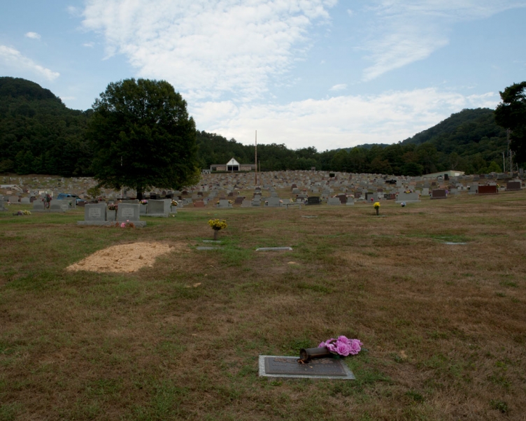
Montgomery Memorial Park was developed in 1933 around the old Wyatt-Tucker-Morris Family cemetery, which dates back to the early 1800's. The park consist of 57 acres of rolling hills and is located about 30 minutes east of Charleston, West Virginia. This image shows a freshly filled grave without a head stone. I thought about how this unmarked unnamed person is at the onset of their perpetual care in memorial park. How much care do the dead need?
archival ink jet print
20" x 25"
2012
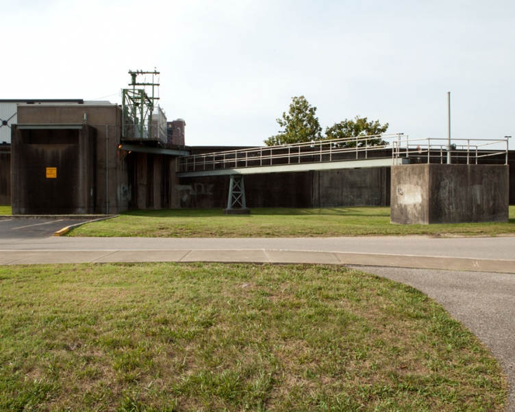
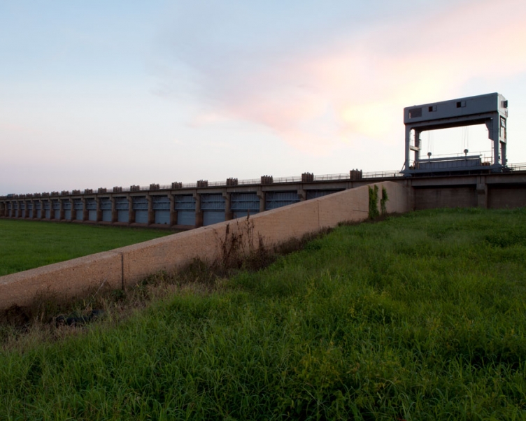
In 1937 the Ohio River flooded causing a tremendous amount of damage to Huntington, West Virginia. Huntingtonians agreed to build a floodwall to surround the 7,060 acres of residences and businesses to prevent additional damages from flooding. The floodwall was built in three sections: Huntington, Westmoreland, and Guyandotte; and consists of 36,900 feet of concrete wall and 24,000 feet of earth levee, with 17 pumping stations and 45 gate openings. This image was made between the Ohio River and the wall in an area designated as Harris River Front Park.

found object
2012
"First of all, I do not suggest going to this park after dark. It can be kind of seedy even in bright daylight, but at night there are issues with unsavory characters wandering the park. That said, I love hanging out in this park. Yes, it needs some facelifting, but it looks significantly better than most places in Huntington. There's lots of places to just sit and watch the river. The amphitheater especially has room to lounge in the sun or shade and read a book while watching the barges go on by. I just wish they'd move the ugly stage boat (or make the stage boat look nicer) when it's not in use. In the summer, they also have quite a few outdoor concerts of various stripes. I haven't attended any of these, but I know lots of folks enjoy them! The flowers here are absolutely gorgeous, whether they be in the huge pots around the flagpoles, or the gardens near the restrooms. There's also a decent amount of walking space, and lots of benches and picnic tables! I spent a fair bit of time here in the summer, and I already miss it." - Yelp review by Paula P., Madison, Wisconsin
archival ink jet print
20" x 25"
2012
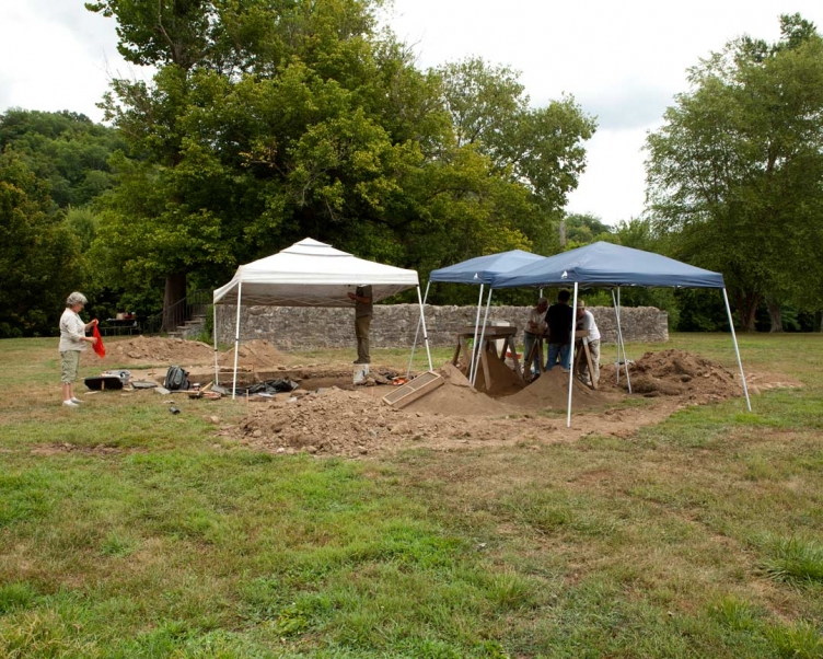
Nancy O'Malley, a UK archaeologist, led a dig at Fort Boonesborough to learn more about the siege of 1778. O'Malley is an expert on Kentucky pioneer settlements and first confirmed Fort Boonesborough's location in 1987. She wasn't just looking for 18th century artifacts, although she found some: a hoe, a skillet, buttons, buckles, bullets, hand-wrought nails, forks, bits of English ceramic and a blue glass trade bead. In this image, O'Malley specifically searched for evidence of the most famous event that occurred there: a nine-day siege in 1778 in which Daniel Boone and a small group of pioneers repelled an attack by several hundred Native Americans. Nancy welcomed me and my camera to her dig, although she didn't want her image made.
archival ink jet print
20" x 25"
2012
The Booker Noe plant produces 15 million gallons of whiskey a year and its mash cookers eat up corn, the main ingredient in bourbon, at a rate of 75 acres a day. The inner workings of the Booker Noe plant are largely unknown to the public. The Booker Noe facility has no tours, and there is no gift shop or tasting room for customers. Ironically enough, Boston, Kentucky is in the dry County of Nelson and the sale of distilled spirits and wine is prohibited.
archival ink jet print
20" x 25"
2012
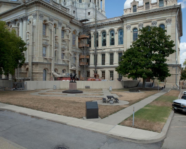
The current Illinois State Capitol is the sixth to serve as capitol since Illinois became a part of the United States in 1818. The capitol is in the architectural style of the French Renaissance. The building is undergoing a $50 million renovation, primarily focused on the west wing, to upgrade life safety, ADA accessibility and mechanical, electrical and plumbing infrastructure as well as architectural improvements to bring the capitol closer to its original 1870s appearance. Improvements include refinishing of interiors and exposed brick arches in the basement; installation of maiden lamp posts for the grand staircase, new chandeliers, and copper-clad exterior doors; and removal of a second floor mezzanine.

found object
2012
While walking near the capitol building in Springfield, I found this weft of hair in the street. At first glance, I thought it was an animal.
archival ink jet print
20" x 25"
2012
The International Union of Operating Engineers Local 520 is a labor organization that provides contractors with Operating Engineers. Local 520 represents over 1800 members in 16 counties of Southern Illinois. Members of Local 520 work in a variety of industries including construction, quarries, mechanic shops, municipalities and private businesses.
archival ink jet print
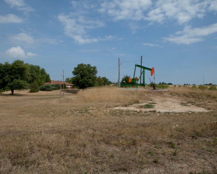
20" x 25"
2012
The home at the intersection of Interstate 64 and Illinois Route 51 has a crude oil pumpjack in its front yard. The air smelled of oil and the earth around the pumpjack is visibly dead.
archival ink jet print
20" x 25"
2012
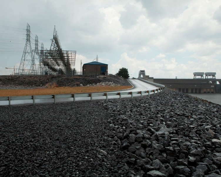
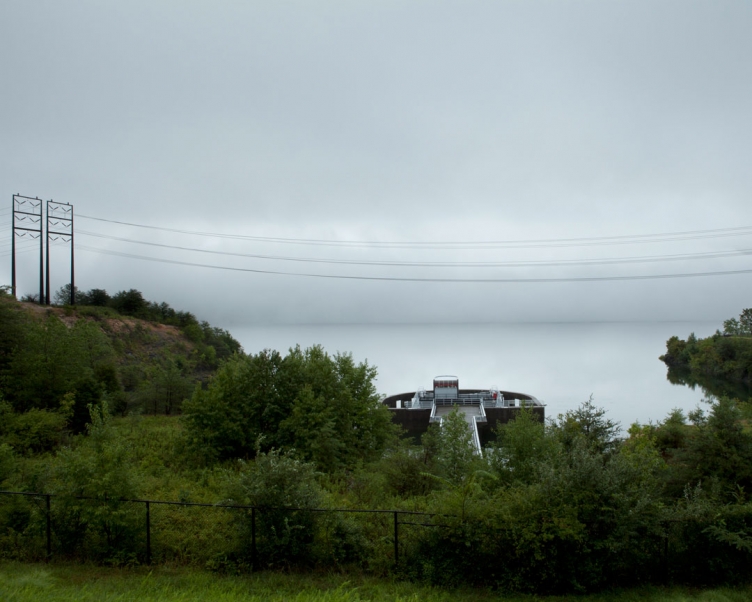
The Kentucky Dam is owned and operated by the Tennessee Valley Authority. It has five generating units with a net dependable capacity of 184 megawatts. Net dependable capacity is the amount of power a dam can produce on an average day, minus the electricity used by the dam itself.
archival ink jet print
20" x 25"
2012
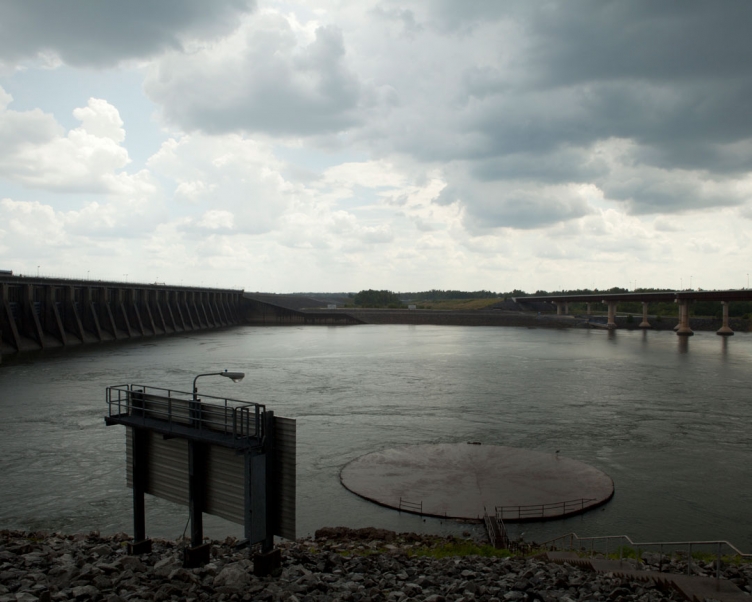
On the downstream side of the Kentucky Dam, water reenters the Tennessee River creating a tailwater. A tailwater refers to the waters immediately downstream from a hydraulic structure which makes conditions ideal for a fishery. The outflow from large dams like the Kentucky Dam have a steep temperature gradient at the tailwater caused by the size of the reservoir with colder water stored at the bottom of the reservoir near the outlet. The constant cold-water flow provided by the reservoir's outflow, coupled with the generally silt-free nature of the outflow, creates ideal water conditions for cold-water fish. The sign in the image prohibits fishing closer to the dam. The circular structure is a velocity barrier used to block the dam's tailrace from migrating fish.
found objects
2012
Land Between The Lakes is an inland peninsula formed when the Cumberland and Tennessee Rivers were impounded, creating Kentucky Lake and Lake Barkley. Kentucky Lake is one of the world's largest man-made bodies of water stretching southward for 184 miles across Kentucky and most of the length of Tennessee to the Tennessee-Alabama line. While driving through LBL, I stopped at the Moss Creek Swimming Point to take a Kentucky Lake bath.
archival ink jet print
20" x 25"
2012
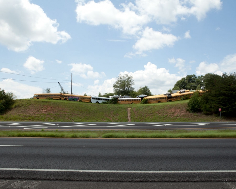
This used auto parts and recycling business purchases all metals from cans to cars. Dale the owner wouldn't allow me on the property - 10 acres of scrap and metals. The entrance to Dale's is lined with school buses visible from the Gainesville Highway.
archival ink jet print
20" x 25"
2012
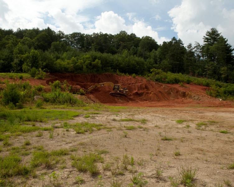
The red clay soils of the Southern United States are also known as Ultisols. They are defined as mineral soils which contain no calcareous (calcium carbonate) anywhere within the soil. This backhoe in North Carolina was clearing a mound of red clay for a home.
archival ink jet print
20" x 25"
2012
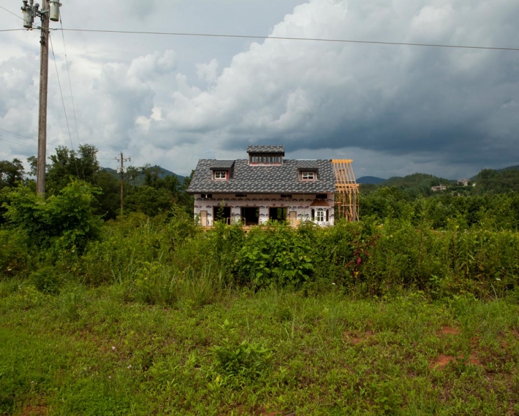
An incomplete build in North Carolina.
found drawing
8.5" x 11"
2012
Found outside the Knoxville Museum of Art.
archival ink jet print
20" x 25"
2012
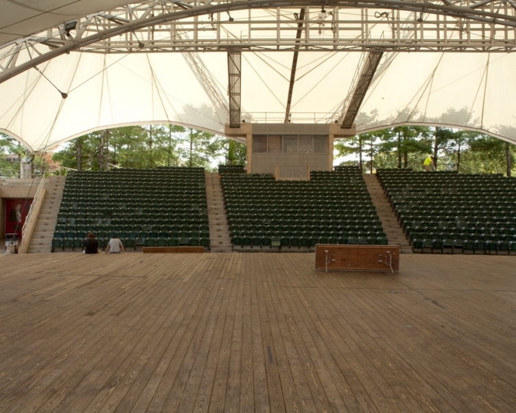
The Tennessee Amphitheater was constructed during the 1982 World’s Fair and during that time, it was home to both country music and classical music concerts. The Sunsphere and the Tennessee Amphitheater are the only structures that remain from the 1982 World’s Fair.
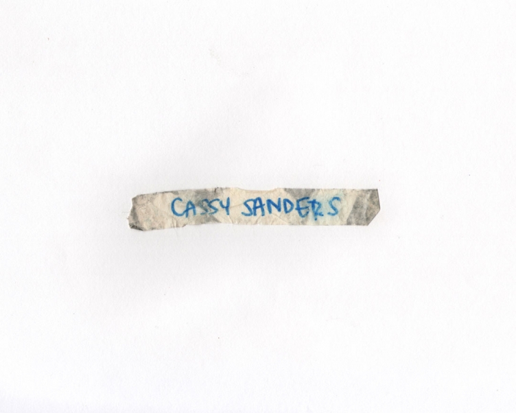
found object
2012
I found this piece of tape stuck to my sock inside my boot. I have no idea who Cassy Sanders is.
given object
11" x 8.5"
2012
Friend and musician Thomas Comerford played a show at The Pilot Light in Knoxville with Joshua Dumas and Robbie Hamilton.
archival ink jet print
20" x 25"
2012
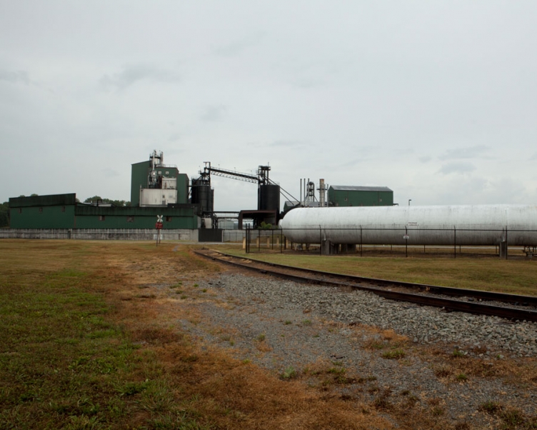
Bull Run Fossil Plant is the only single-generator coal-fired power plant in the TVA system. When the generator went into operation in 1967, it was the largest in the world in the volume of steam produced. Electricity is generated at Bull Run by heating water in a boiler to produce steam. Under extremely high pressure, the steam flows into a turbine that spins a generator to make electricity. Bull Run generates about 6 billion kilowatt-hours of electricity a year, enough to supply about 400,000 homes. It has been ranked the most-efficient coal-fired plant in the nation 13 times and is consistently in the top five each year. Since America has become more vigilant, its difficult to make images of Generating Stations. This was not the first time security asked me to leave a property.
archival ink jet print
20" x 25"
2012
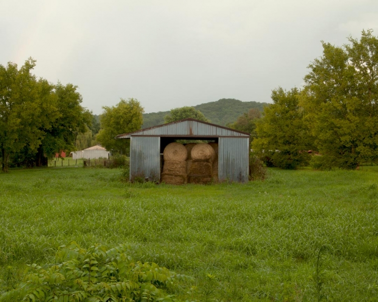
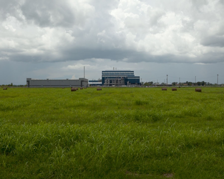
These round bales typically weigh 300 to 400 kilograms (660–880 lb) and are more moisture-resistant, and pack the hay more densely at the center. Hay or grass is the foundation of the diet for all grazing animals and can provide as much as 100% of the fodder required for an animal. Hay is usually fed to an animal in place of allowing the animal to graze on grasses in a pasture, particularly in the winter or during times when drought or other conditions make pasture unavailable.
archival ink jet print
20" x 25"
2012
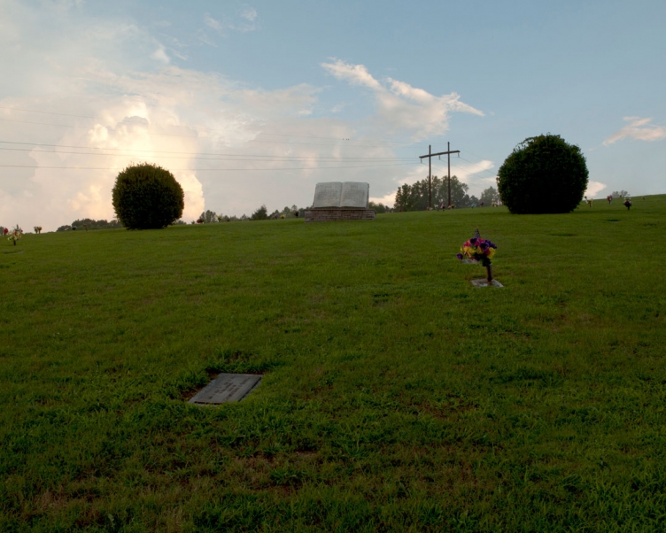
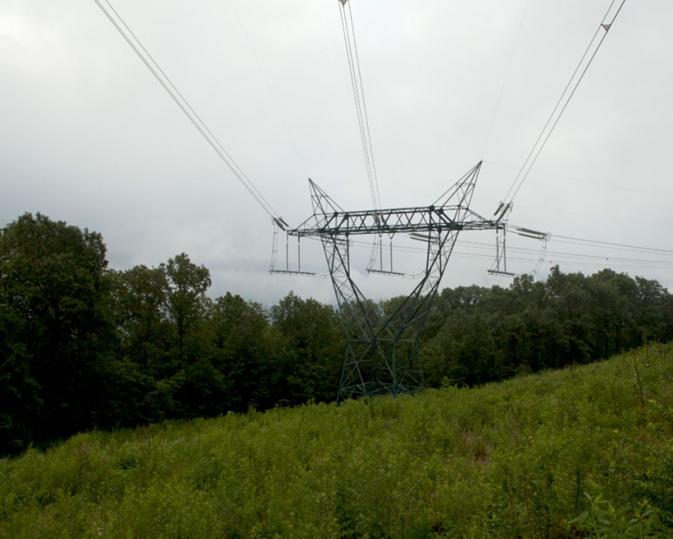
I am fascinated by the rituals of caring for the deceased. We celebrate with ceremony and immortalize passed lives with gardens and green spaces. Memorialization provides solemn ground for the dead and offers comfort to the breathing. This image references spiritual power beyond the conspicuous devotion. The cloud grouping alludes to the old testament's account of the burning bush. The poles carrying electrical power lines resemble a double cross.
archival ink jet print
20" x 25"
2012
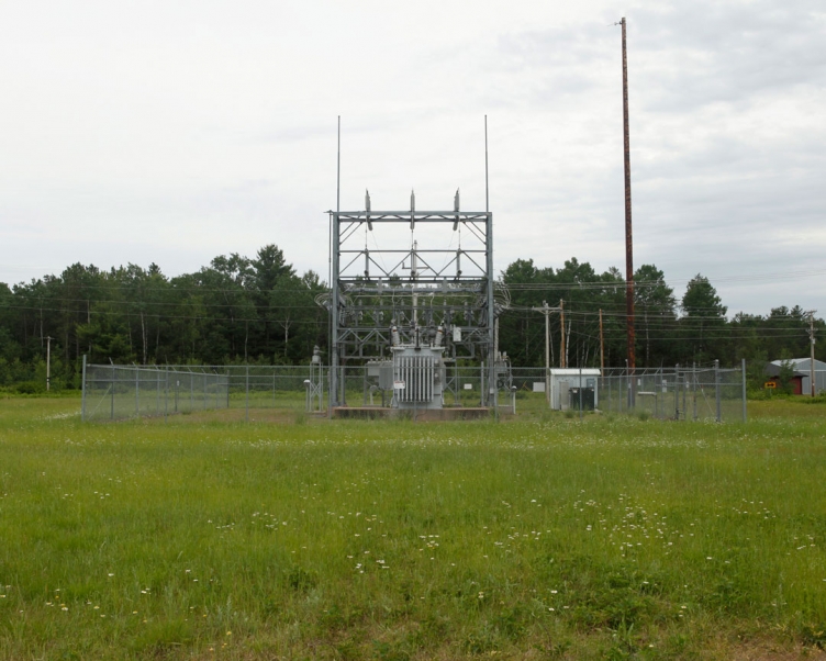
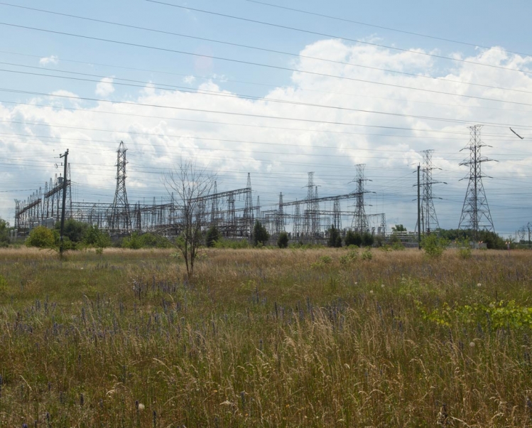
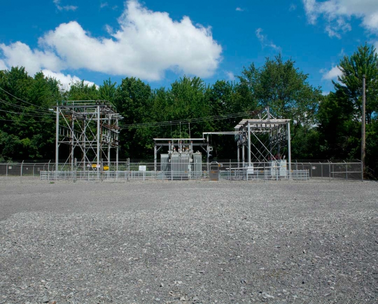
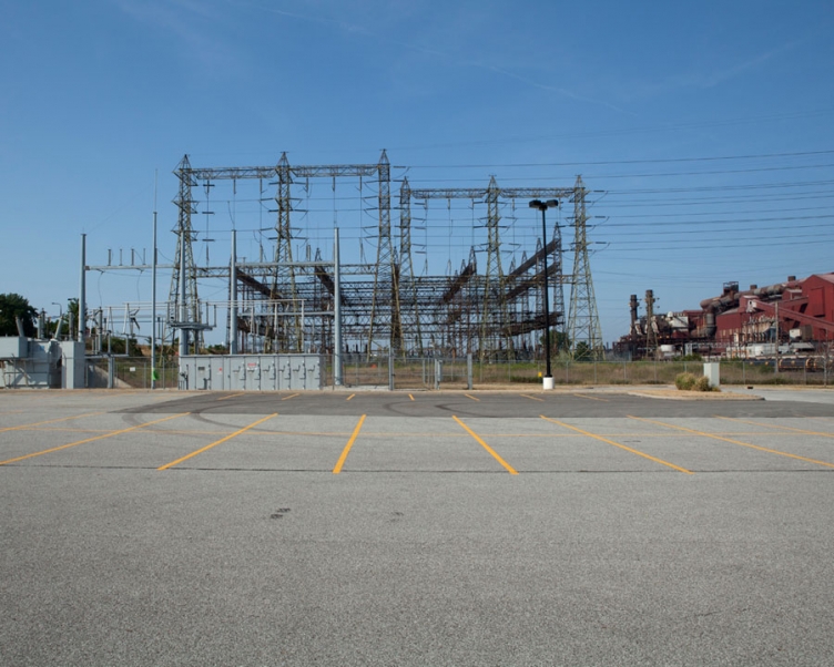
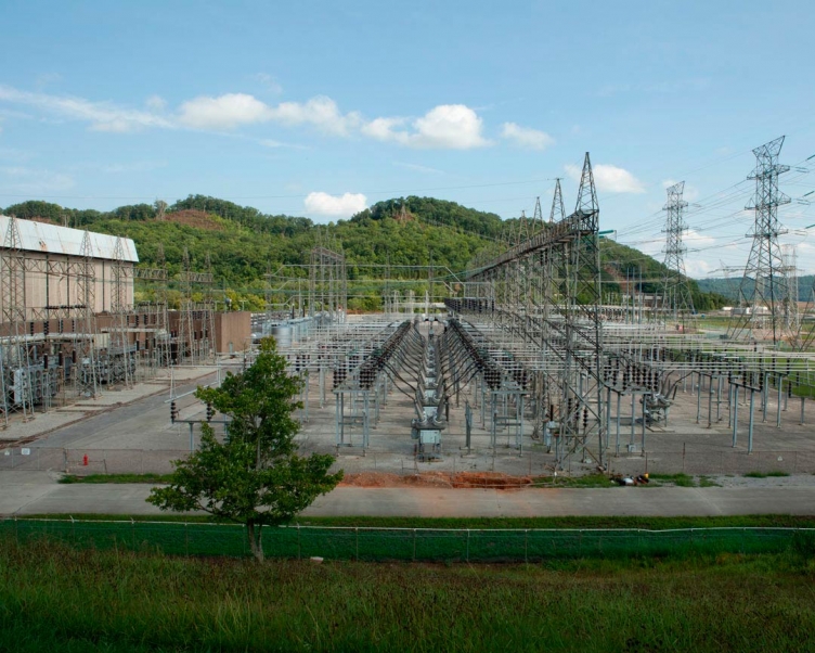
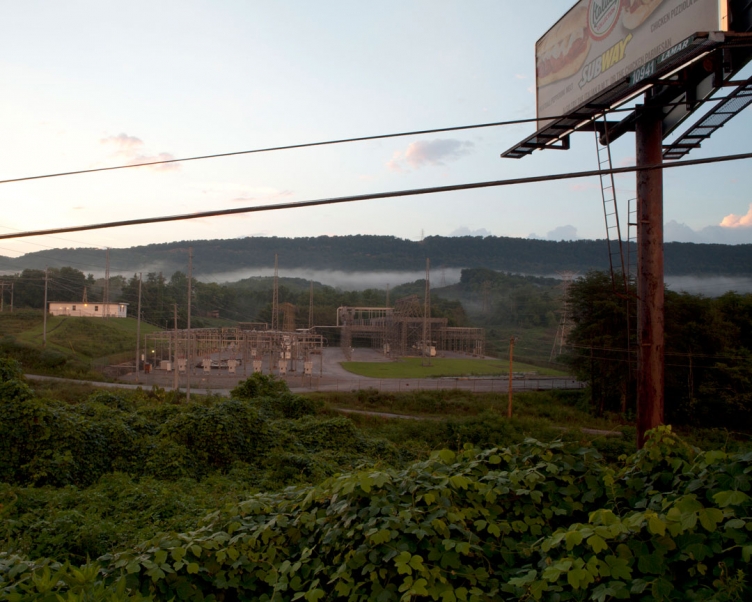
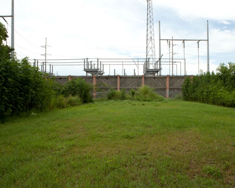
Rockwood, Tennessee is situated at the base of the eastern escarpment of the Cumberland Plateau, known locally as Walden Ridge. This substation serves the city of Rockwood with power managed by the Tennessee Valley Authority. Interrupting the foreground of the image are additional power lines and advertising.
archival ink jet print
20" x 25"
2012
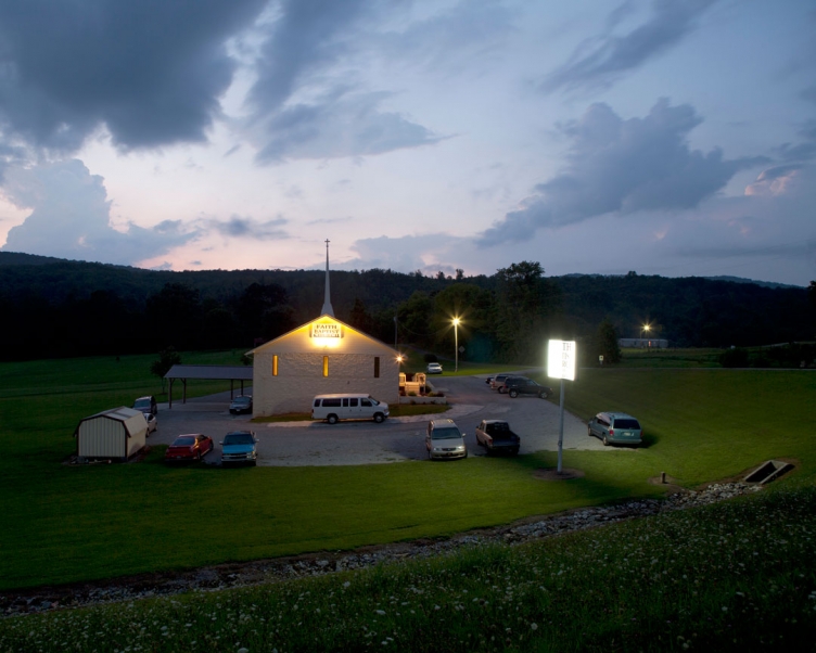
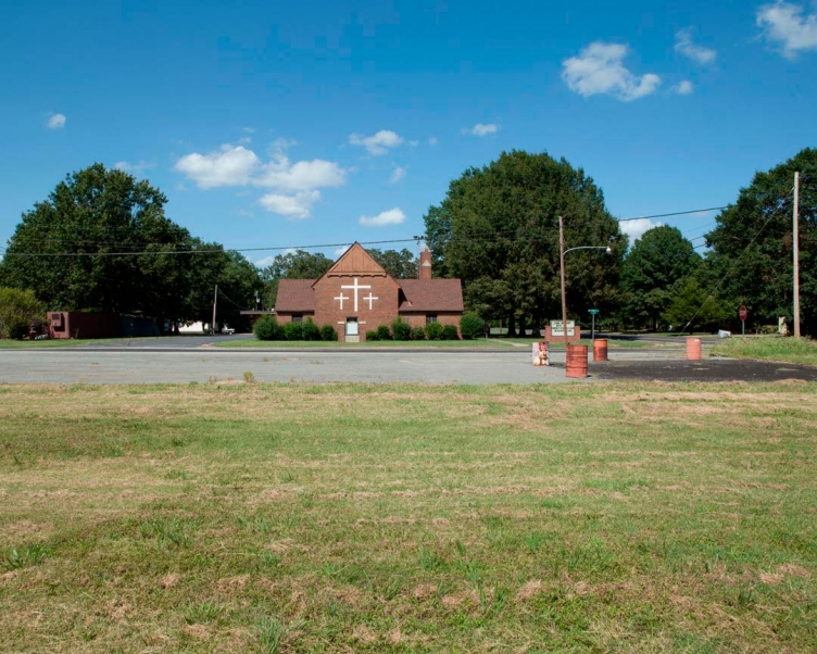
The Bible Belt is an informal term for a region in the south-eastern and south-central United States in which socially conservative evangelical Protestantism is a significant part of the culture and Christian church attendance across the denominations is generally higher than the nation's average. Temperance-inclined Baptist churches generally promote literal interpretations of the Bible and subscribe to a doctrine that baptism should be performed only for professing believers (believer's baptism, as opposed to infant baptism), and that it must be done by complete immersion.
archival ink jet print
20" x 25"
2012
archival ink jet print
20" x 25"
2012
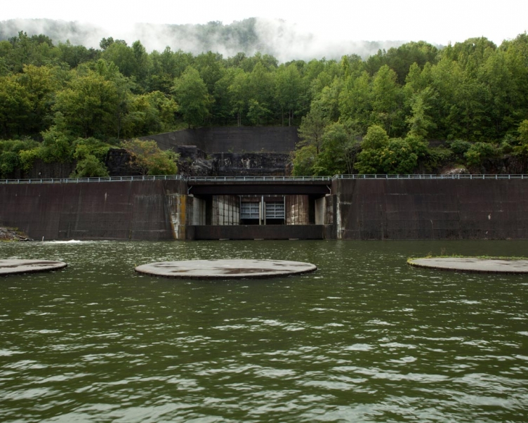
Raccoon Mountain Pumped-Storage Station is a hydroelectric facility located in southeast Tennessee on a site that overlooks the Tennessee River near Chattanooga. The reservoir constructed at the top of the mountain has 528 acres of water surface. The dam at Raccoon Mountain’s upper reservoir is 230 feet high and 8,500 feet long. It’s the largest rockfill dam ever built by the Tennessee Valley Authority. When demand is high, water is released via a tunnel drilled through the center of the mountain to drive generators in the mountain’s underground power plant.
archival ink jet print
20" x 25"
2012
Water released through the Raccoon Mountain upper reservoir is discharged into the Tennessee River. During periods of low demand, the generating turbines run in reverse pumping water from Nickajack Reservoir at the base of the mountain to the reservoir built at the top. It takes 28 hours to fill the upper reservoir.
archival ink jet print
20" x 25"
2012
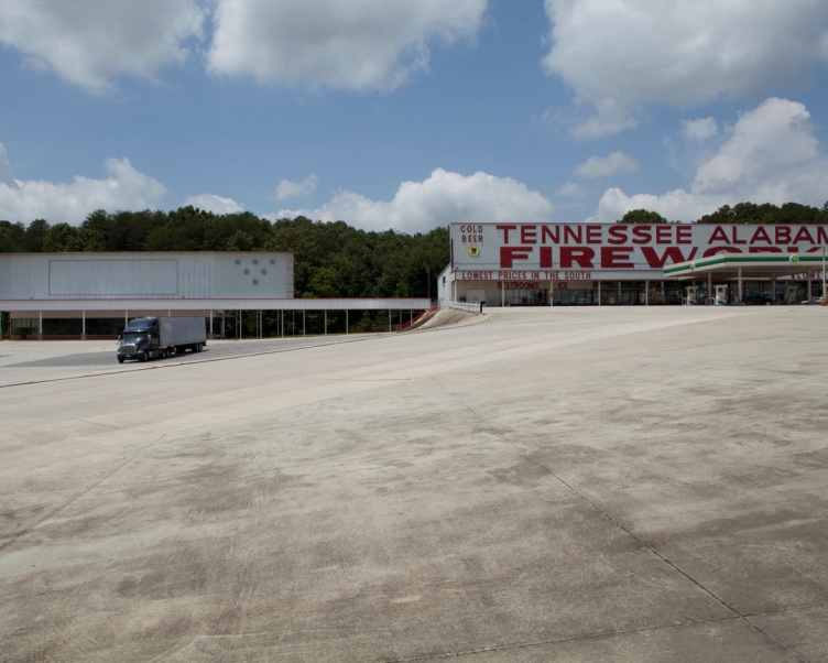
Tennessee Alabama Fireworks operates three locations along the state's borders. This site in Jasper, Tennessee hosts a BP fueling station and doubles as a truck stop. To enhance your fireworks experience you can also purchase gifts, novelties, lotto, and cold beer. They boast to have the lowest firework prices in the south.
archival ink jet print
20" x 25"
2012
archival ink jet print
20" x 25"
2012
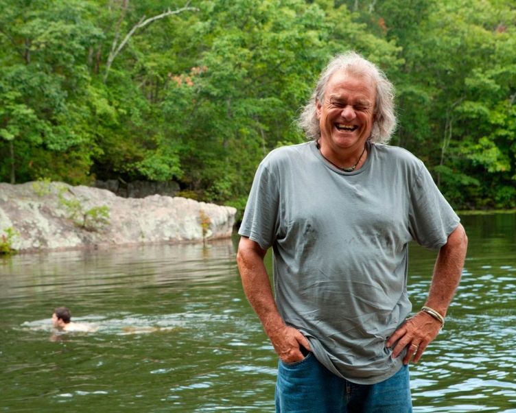
In Nashville, I caught friend Mr. Jimmy play a country music show at the Basement. While talking about my project and spiritual power with his bandmate Herschel Van Dyke, he suggested I visit his father The Reverend Dr. Bude Van Dyke in Sewanee. The Reverend Van Dyke is chaplain at St. Andrew’s, the Episcopal Day and Boarding School. Bude spoke candidly about his varied past and how he found his path to love (and god). The Reverend took me to this reservoir where he enjoys meditating - of course, on this hot summer day there was a group of swimmers.
archival ink jet print
20" x 25"
2012
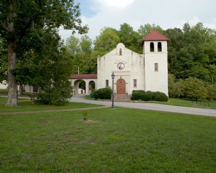
The Episcopal chapel on the campus of St. Andrew's-Sewanee School where The Reverend Bude Van Dyke is chaplain.
archival ink jet print
20" x 25"
2012
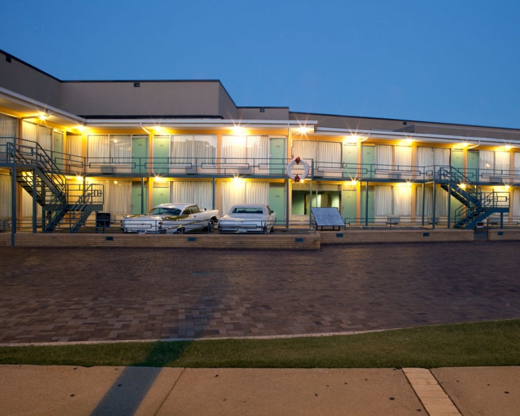
The Lorraine Motel is the site where Martin Luther King, Jr. was assassinated on April 4, 1968. The Lorraine Motel is part of the National Civil Rights Museum - a privately owned complex of museums and historic buildings which traces the history of the Civil Rights Movement in the United States from the 17th century to the present. Room 306 (the room King was assassinated in front of) and the adjoining room 307 have been unoccupied as a memorial to King.
video/6:45' loop
2012
This video examples the solemn atmosphere of the Lorraine Motel. However, just down the street from this memorial, Jacqueline Smith has maintained a protest vigil across the street from the Lorraine Motel for up to 21 hours per day for over 25 years, regardless of weather. Jacqueline Smith had resided at the Lorraine Motel since 1973 as part of her work for the motel as a housekeeper. When faced with eviction for the museum project, Smith barricaded herself in her room and had to be forcibly evicted. Smith stated that the Lorraine "should be put to better uses, such as housing, job training, free college, clinic, or other services for the poor... the area surrounding the Lorraine should be rejuvenated and made decent and kept affordable, not gentrified with expensive condominiums that price the people out of their community."

found object
2012
In China, the phrase "to shed off the golden cicada skin" is the poetic name of the tactic of using deception to escape danger, specifically of using decoys (leaving the old shell) to fool enemies. In Japan, the cicada is seen as a symbol of reincarnation since it emerges from the ground to sing every summer. Furthermore, the cicada moults, leaving behind an empty shell, but since the cicada lives for only a short time, long enough to attract a mate with its song and complete the process of fertilization, they are seen as a symbol of evanescence.
archival ink jet print
20" x 25"
2012
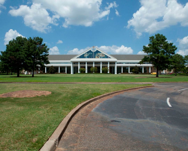
Bellevue Baptist Church is a large Southern Baptist megachurch in the Cordova area of Memphis. Bellevue is the largest church in Memphis and is one of the leading churches in the Southern Baptist Convention. Bellevue's goals are to "Love God, Love People, Share Jesus, and Make Disciples." This building has a 7,000 seat worship center, a family life center, preschool wing, athletic complex, and a multipurpose wing complete with a bookstore and cafe.
archival ink jet print
20" x 25"
2012
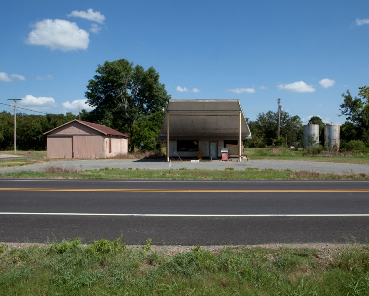
Abandoned single pump gas station in Stuttgart, Arkansas.
archival ink jet print
20" x 25"
2012
Zion Lutheran Church was established in Ulm, Arkansas in 1881. The city is named after the southern German city. The population of Ulm as of 2012 was 167.
archival ink jet print
20" x 25"
2012
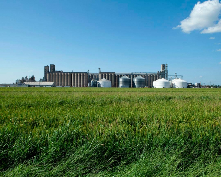
Riceland Foods, Inc., is a farmer-owned agricultural marketing cooperative and the world's largest miller and marketer of rice. The company was founded in 1921 with headquarters in Stuttgart, Arkansas. Riceland owns and operates seven rice mills including the largest rice mill in the world. The core purpose of this farmer-owned cooperative is to generate enhanced revenue and returns for its membership.
archival ink jet print
20" x 25"
2012
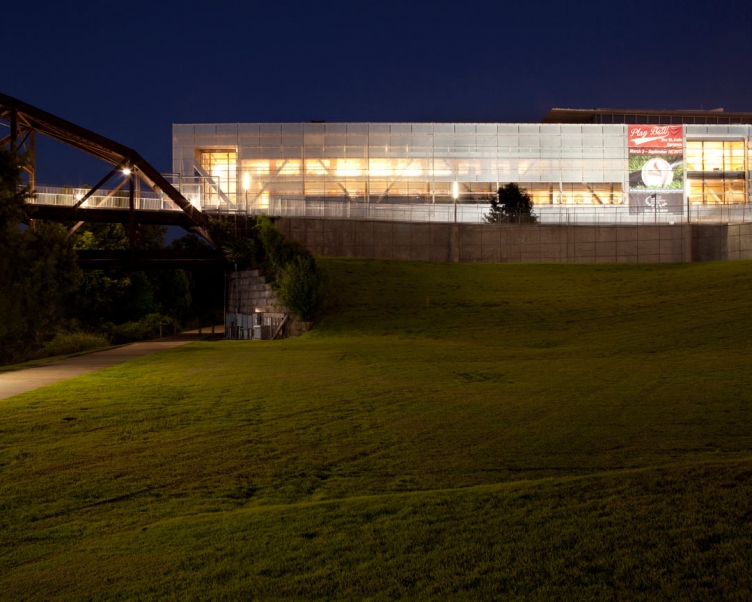
The William J. Clinton Presidential Center and Park is the presidential library of Bill Clinton, the 42nd President of the United States (1993–2001). It is located in Little Rock, Arkansas and includes the Clinton Presidential Library, the offices of the Clinton Foundation, and the University of Arkansas Clinton School of Public Service.
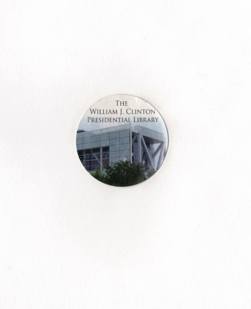
found object
2012
I didn't go in... I just found this sticker outside the library.
archival ink jet print
20" x 25"
2012
Bowie County Correctional Center was built and opened in 1993. The Center can hold 740 adult males and females. Bowie County Correctional Center is classed as a medium security facility. It has a strengthened perimeter fence and electronic detection systems to ensure inmates stay within the facility. To help inmates prepare themselves to rejoin the wider community, Bowie County Correctional Center offers a wide range of work and treatment programs. Bowie County Correctional Center is a County Jail used by the jurisdictions of Bowie to confine inmates for short periods while awaiting trial or processing. As inmates are staying for only a short period, it has fewer amenities than a jail or prison. Inmates do, however, have access to bathroom facilities and are provided with meals during their stay. Bowie County Correctional Center may also have a common area in which inmates can socialize.
archival ink jet print
20" x 25"
2012
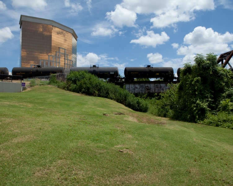
Horseshoe Bossier City is a riverboat casino located in Bossier City, Louisiana, across the river from Shreveport. Horseshoe Bossier City has 606 suites in its 25-story hotel tower. Horseshoe has over 1,500 slot machines and over 60 table games. Horseshoe has over 200 video poker machines, and a 14-table poker room.
archival ink jet print
20" x 25"
2012
John Overton Lock And Dam, also known as Lock No. 2 is a gravity dam. The core is earth. The foundation is soil. Its length is 914 feet. Lock No. 2 is impounded by John Overton Lock and Dam on the Red River in Rapides County, Louisiana and is used for improved navigation and recreation purposes. Construction was completed in 1987. It has a normal surface area of 5.9 square miles. It is owned by the U.S. Army Corps of Engineers.
archival ink jet print
20" x 25"
2012
The Red River of the South meanders 1,360 miles through Texas, Arkansas and Louisiana before empting into the Mississippi River. It forms the border between Texas and Oklahoma for significant distances.
archival ink jet print
20" x 25"
2012
The Morganza Spillway or Morganza Control Structure is a flood-control structure along the western bank of the Mississippi River at river mile 280, near Morganza in Pointe Coupee Parish. The spillway stands between the Mississippi and the Morganza Floodway, which leads to the Atchafalaya Basin and the Atchafalaya River in south-central Louisiana. Its purpose is to divert water from the Mississippi River during major flood events by flooding the Atchafalaya Basin, including the Atchafalaya River and the Atchafalaya Swamp. The spillway and adjacent levees also help prevent the Mississippi from changing its present course through the major port cities of Baton Rouge and New Orleans to a new course down the Atchafalaya River to the Gulf of Mexico. The Morganza Spillway, operated by the U.S. Army Corps of Engineers, was opened during the 1973 and 2011 Mississippi River floods.
archival ink jet print
20" x 25"
2012
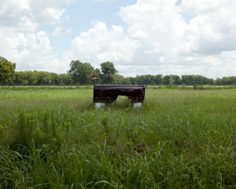
Purple truck bed for sale by owner in the middle of a field.
archival ink jet print
20" x 25"
2012
Criterion catalysts can be currently found in about 60 of the world’s hydrocracking units and around 850 hydrotreating units used for a variety of applications. Hydrocracking is process by which the hydrocarbon molecules of petroleum are broken into simpler molecules, as of gasoline or kerosene, by the addition of hydrogen under high pressure and in the presence of a catalyst. Criterion also produces catalysts for diesel dewaxing, which is used to reduce the cloud point and improve the cold flow properties. In addition, a large proportion of the ebullated-bed residue upgrading units around the world contain Criterion catalysts, as do the majority of tail-gas treating units.
archival ink jet print
20" x 25"
2012
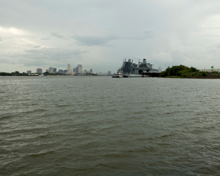
Southeast of the French Quarter, in an eastern neighborhood called Bywater, there's a levee locals affectionately call The End of the World. The levee jets into the Mississippi under the shadow of the East Bank Naval Clinic, a set of three desolate buildings decommissioned in 2011, and is bordered by Industrial Canal. The city rents the dock to commercial tankers until it decides how to develop the clinic's 23-acre plot. The real reason the levee is called The End of the World, is that the Bywater neighborhood is the last above sea level. I made this image from the Lower 9th - directly across from The End of the World. Depending on where you stand (or live), The End of the World has paradoxical significance.
archival ink jet print
20" x 25"
2012
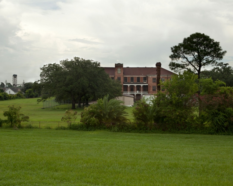
Holy Cross was an all boys Catholic school located just across from The End of the World in the Lower 9th Ward. With Hurricane Katrina, the campus was flooded by the Levee failures on the Industrial Canal and levee "over-topped" by storm surge along the Mississippi River Gulf Outlet that destroyed St. Bernard Parish and Eastern New Orleans. Since the flood destroyed the school, it has relocated to the Gentilly/7th Ward neighborhood of New Orleans.
archival ink jet print
20" x 25"
2012
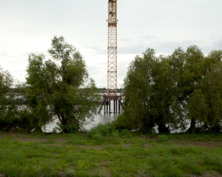
An operating crane on the Mississippi River adjacent to the Holy Cross campus.
archival ink jet print
20" x 25"
2012
archival ink jet print
20" x 25"
2012
An empty lot where a home once stood in the Lower 9th. The address is scratched into the driveway cement.
archival ink jet print
20" x 25"
2012
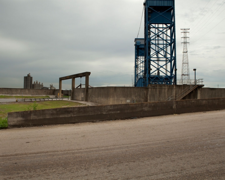
The Florida Avenue Bridge is a vertical lift bridge spanning the Industrial Canal in New Orleans, Louisiana. It connects the Lower 9th with the Upper 9th Ward.
archival ink jet print
20" x 25"
2012
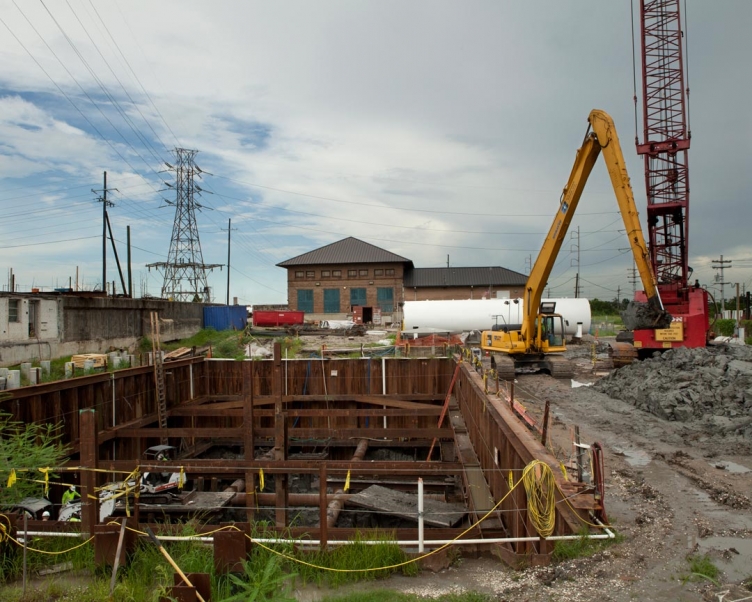
During Hurricane Katrina in 2005, the pump in the Lower Ninth Ward, near Florida Avenue failed. In 2012, The US Army Corps of Engineers are still storm proofing the pumps by installing two new generators and drainage.
archival ink jet print
20" x 25"
2012
The former Naval Support Activity site overlooks the confluence of the Mississippi River and the Inner Harbor Navigation Canal, or Industrial Canal, and includes three large buildings on 25 acres of land. The Bywater installation was once home to the national headquarters for the Navy and Marine Corps reserve. The city acquired the site from the Navy and hopes to redevelop the site as a resilience center - a hub for disaster and emergency response agencies.
archival ink jet print
20" x 25"
2012
The Grand Palace Hotel was a seventeen story building located in the Mid City area of New Orleans, Louisiana, America. The building was imploded 22 July 2012. The building opened as an apartment complex in 1951 and featured a wide range of facilitators and occupiers, including 5 different hotel names and a senior citizens residence.
archival ink jet print
20" x 25"
2012
Upon close inspection, the draped billboard was a faded advert for Robin Motor Co. - still in business in Jeanerette. The draped billboard resembles linens left hanging on the cross after the resurrection of Jesus. Perhaps symbolic of our American need and faith in product.
archival ink jet print
20" x 25"
2012
Spoetzl Brewery produces the popular line of Shiner Beers distributed in 48 states. Spoetzl was founded in 1909, and is the oldest independent brewery in Texas. Shiner Bock is a favorite beer within the Texas Country music scene. Expecting to find nothing but Oil and Industrial Power in Texas, I was surprised to be invited inside for a beer.
archival ink jet print
20" x 25"
2012
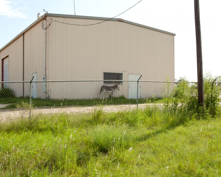
A donkey taking refuge from the 110 degree Texan heat. Making this image, I discovered the difference between a mule and donkey. A mule is the offspring of a male donkey (jack) and a female horse (mare). Charles Darwin wrote: "The mule always appears to me a most surprising animal. That a hybrid should possess more reason, memory, obstinacy, social affection, powers of muscular endurance, and length of life, than either of its parents, seems to indicate that art has here outdone nature."
given object
2012
archival ink jet print
20" x 25"
2012
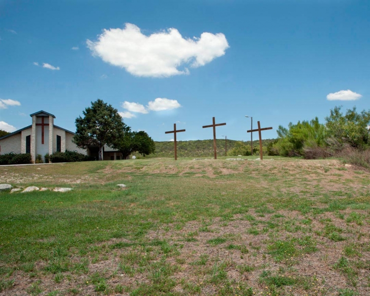
Most of Texas is considered part of the Bible Belt. The three crosses in the church yard symbolize the crucifixion of Jesus flanked by two thieves. As my travels progressed I began to feel cross-crazy and saw the religious symbol in any two lines that intersect - including several additional crosses in this image.

found objects
2012
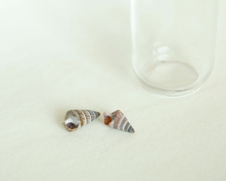
I was surprised to find shells in the earth while making an image in Texas - no where near water.
archival ink jet print
20" x 25"
2012
The only place of worship I found without a cross to designate it as a church. "Meets Here Sunday 10:30."
archival ink jet print
20" x 25"
2012
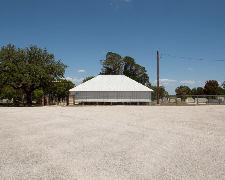
"Some of the earliest pioneers of the Oatmeal Community are interred in this cemetery. The oldest documented burials are those of Mary Smith and her year-old daughter, Fanny, both of whom died on Sept. 16, 1854. Mr. and Mrs. J. L. Roundtree deeded the two acres of land containing the cemetery in 1871. Among those interred here are veterans of the Civil War, World War I, and WWII. An additional land acquisition in 1983 enlarged the cemetery to 3 acres."
archival ink jet print
20" x 25"
2012
On April 20, 1993 the ATF raided, then besieged, then attacked the fortified compound that the Koreshians called Mount Carmel. In the siege, four ATF agents and 80 followers of Vernon Howell, a.k.a. David Koresh, and his splinter group of Branch Davidian Seventh Day Adventists. There are no signs of the compound any more; the only remnant is a hole, formerly a swimming pool that was used as a bunker during the siege. This image is of a little chapel finished in 1999 by the Koreshians and their supporters, incorporating an infrequently-open museum of Davidian history that censures everyone for the bloodshed.
archival ink jet print
20" x 25"
2012
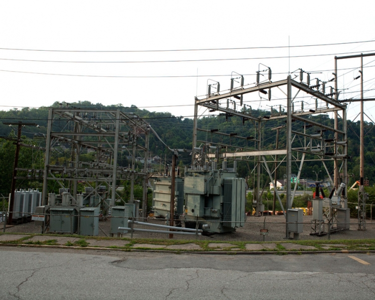
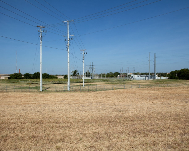
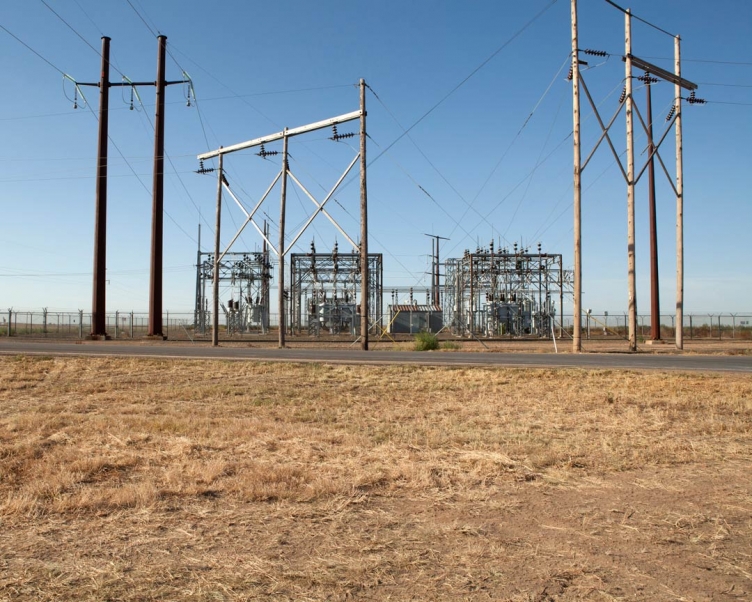
Rogers Hill (BEPC), POD Switchyard FM 1858. 1.7 miles north of Gholson, McLennan County.
archival ink jet print
20" x 25"
2012
archival ink jet print
20" x 25"
2012
archival ink jet print
20" x 25"
2012
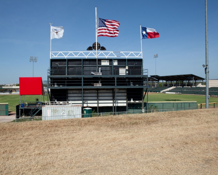
LaGrave Field is a stadium primarily used for baseball, and is the home field of the Fort Worth Cats independent minor league baseball team. Legends maintain that the Texas state flag is entitled to fly at the same height as the American flag and Texas may exercise certain privileges not granted to other states due to its status as a quasi-independent republic prior to its admission to the United States.
archival ink jet print
20" x 25"
2012
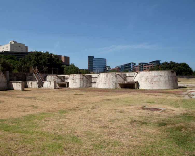
The Riverside WWTP operated from 1920 until 1979. Its Peak operation size was 143 acres. The relic buildings, clarifiers, trickling filters, sludge digesters, and sludge lagoons remain in place. Plans for current WWTP and sludge lagoon sites include an amphitheater and river education center, as well as a lake and wetlands in the former sludge lagoons.
archival ink jet print
20" x 25"
2012
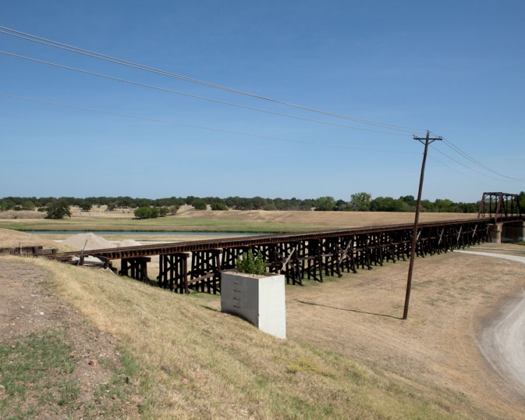
In 1875 former Fort Worth lawyer, Robert E. Cowart, wrote that the decimation of Fort Worth's population, caused by economic disaster and harsh winter of 1873, had dealt a severe blow to the cattle industry. He further stated that the harm to the cattle industry, combined with the fact that the railroad company had stopped laying track 30 miles outside of Fort Worth, had caused the city to become so drowsy that he saw a panther asleep in the street outside of the courthouse. Although an intended insult, the nickname Panther City was embraced by Fort Worth when Forth Worth recovered from the depression with the arrival of the railroad in 1876. The Fort Worth and Western Railroad is a Class III short-line railroad headquartered in Fort Worth. This stretch of the line bridges the Trinity River and is the western border of the Trinity River Plan and Vision to create a vibrant, pedestrian-oriented urban waterfront neighborhood adjacent to Downtown Fort Worth.
archival ink jet print
20" x 25"
2012
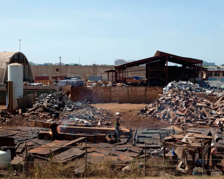
Gachman was founded in 1913 by Russian immigrant Jacob Gachman, and the company remains family owned and operated through four generations. Gachman processes all types of scrap metals, from low-grade iron to space age titanium. They prepare ferrous and non-ferrous scrap through a variety of methods including sorting, shredding, shearing or cutting, bailing, briquette or breaking.
archival ink jet print
20" x 25"
2012
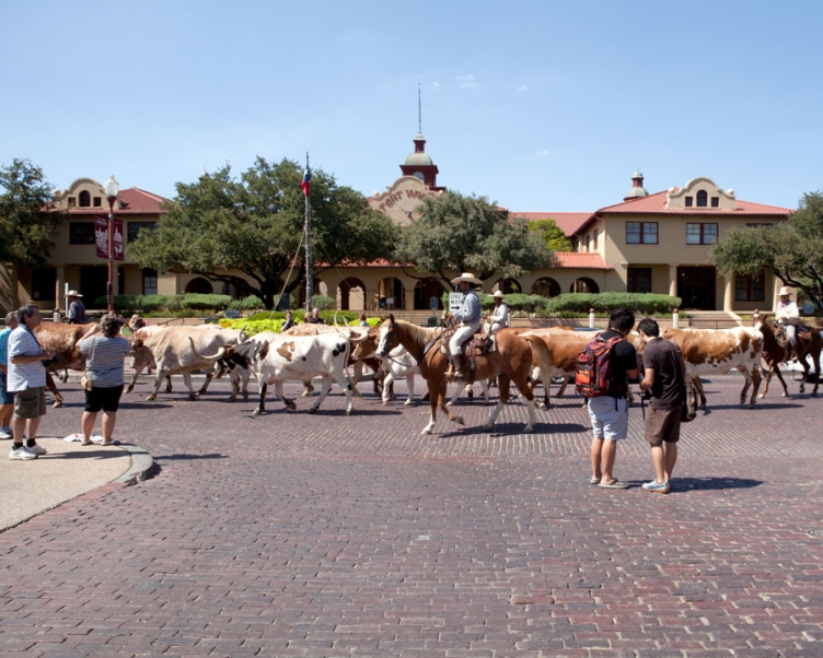
The arrival of railroads in 1876 made the Fort Worth area a very important livestock center. By 1886, four stockyards had been built near the railroads. Boston capitalist Greenleif W. Simpson, with a half dozen Boston and Chicago associates, incorporated the Fort Worth Stock Yards Company on March 23, 1893, and purchased the Union Stock Yards and the Fort Worth Packing Company. By 1907, the Stockyards sold a million cattle per year. The stockyards was an organized place where cattle, sheep, and hogs could be bought, sold and slaughtered. Fort Worth remained an important part of the cattle industry until the 1950s. Today The Stockyards consist of mainly entertainment and shopping venues that capitalize on the "Cowtown" image of Fort Worth. Twice daily Texas cowhands drive a herd of fifteen Texas Longhorns through the Fort Worth Stockyards Historic District, each steer representing one decade of the Stockyards existence.
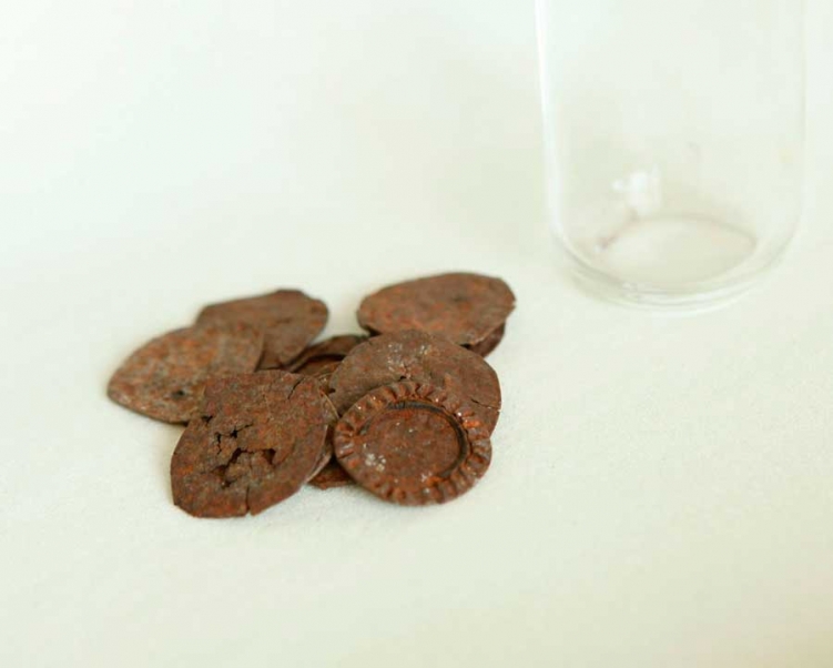
found objects
2012
After watching the historic Longhorn drive I consumed several beers in the Stockyards District. In the bar I met a cattle driver clad in authentic 19th century clothing named Bryan Hinkle. He was full of information about the history of the stockyards including how a meat famine in the 1860's influenced the creation of the Fort Worth Stockyards and the last shoot out in Fort Worth between Luke Short and Jim Courtright in 1887. I found these flattened beer bottle caps in the street outside the bar. The brief history lesson got me to thinking about enjoying a cold beer after a long cattle drive and the story behind these rusted caps.

archival ink jet print
20" x 25"
2012
After a long day of driving and making photographs, I met Tina Pack at a local Fort Worth dive bar called The Chat Room. She was interested in my travels and photographic exploration. She offered her couch to me with one stipulation - she had to pick up her husband Carl at 4am who was serving weekends in jail for his 3rd DWI. She described Carl as 6'5", 300 lbs with a temper. Oh yeah, and he had one leg. Needless to say I didn't want the enormous, angry, one-legged Carl to come home to a stranger on his couch and I slept in my car. I met Carl and his family the next day at Fred's Cafe where Carl was a manager. He bought my burger. Carl lost his leg to cancer at 17. He prefers to use crutches because prosthetics pinch his balls. He was one of the founders of the Wreck Room - a punk bar in Fort Worth until it was closed because of city re-development. Carl's band, The Gideons, played the Wreck’s first show in 1997 and final show in 2007. Carl and I went drinking later that night and everyone new him. He didn't pay for a single drink. After learning more about Carl, I spent the night on his couch.
archival ink jet print
20" x 25"
2012
Dublin Dr. Pepper was the popular name for a style of Dr. Pepper soft drink made by the Dublin Dr. Pepper Bottling Company in Dublin, Texas. Dublin Dr. Pepper followed the original recipe, using cane sugar as the sweetener as opposed to newer high-fructose corn syrup. According to the corporate headquarters at Dr. Pepper Snapple Group, this resulted in clashes with other bottlers and the parent company of Dr. Pepper. On 12 January 2012, it was announced that Dublin Dr. Pepper will no longer be produced, after the Dublin Dr. Pepper Bottling Company sued the Dublin Dr. Pepper Bottling Company. Dr Pepper Snapple Group, the third-largest U.S. soda company with 2010 revenue of $5.6 billion, accuses the Dublin bottler of trademark dilution and stealing sales from other Dr. Pepper bottlers by selling outside its approved territory.
archival ink jet print
20" x 25"
2012
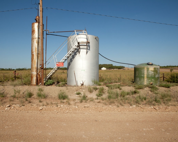
Bob Isbell Operating Agnew Lease, 110 AC. RRC#15704, Co. Rd. 134
archival ink jet print
20" x 25"
2012
Bob Isbell Operating Arlin Bint Lease, RRC#16845, 86 acres, I-20 Frontage Rd., Operating Lease Well #5
archival ink jet print
20" x 25"
2012
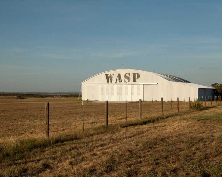
The WASP (Women's Airforce Service Pilots) filled a tremendous void in the military forces of 1943-1944 following the attack on Pearl Harbor. Some 25,000 women applied to join the WASP, but only 1,830 were accepted and took the oath. Only 1,074 of them passed the training and joined. Thirty-eight died flying in the WASP. The planes the women flew were dangerous and the terrain created special hazards for would-be pilots. Training was hurried and problems were frequent. Many believed women could not make viable pilots. When the missions were finished, the war was over and the women returned to civilian life, their contributions went largely unrecognized and wholly unrewarded. The WASP wasn't granted veteran status until 1977, and given the Congressional Gold Medal in 2009.
archival ink jet print
20" x 25"
2012
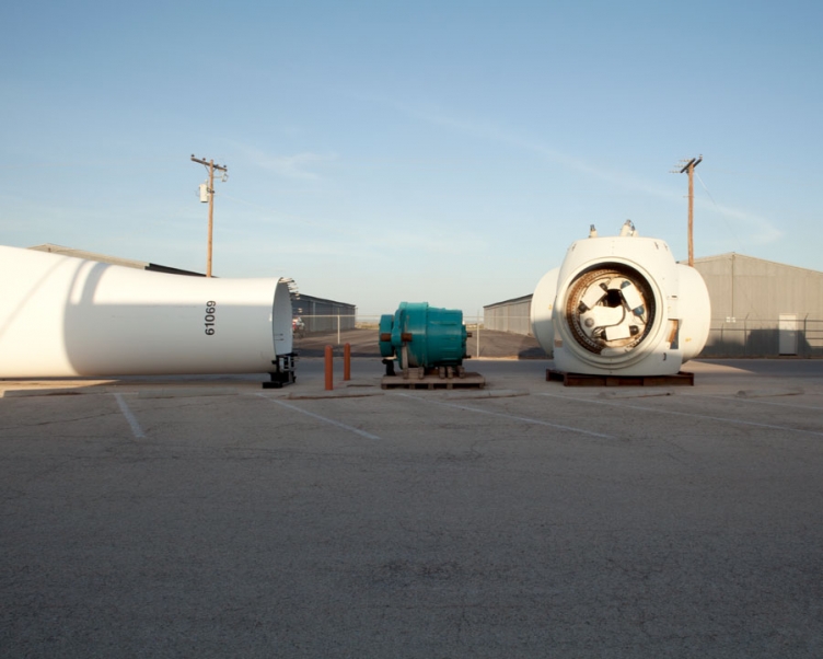
The TSTC Wind Energy Turbine and Technology department incorporates various labs, trainers, and equipment into their training curriculum. TSTC has its own Wind Turbine capable of producing 2 MW of energy at peak production. The tower is available to students for an initial climb test, as well as for additional subsequent climbs for cleaning and routine tower maintenance. Students also learn proper procedures for generator to gearbox alignments, torquing, installation of components and boroscoping of the gearbox.
archival ink jet print
20" x 25"
2012
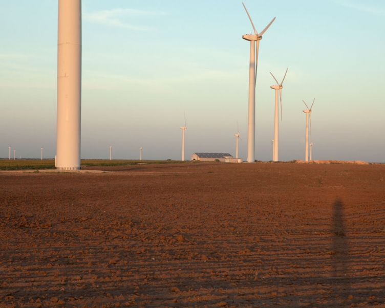
Wind power in Texas consists of many wind farms with a total installed nameplate capacity of 12,212 MW from over 40 different projects. Texas produces the most wind power of any U.S. state. Wind power accounted for 8.3% of the electricity generated in Texas during 2013.
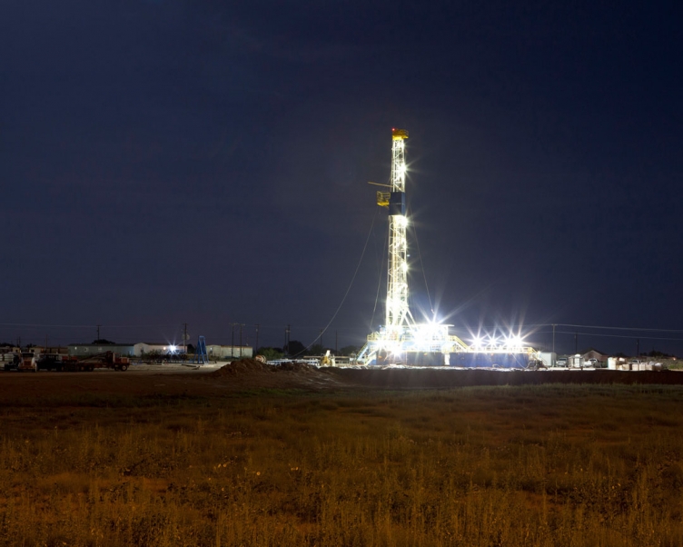
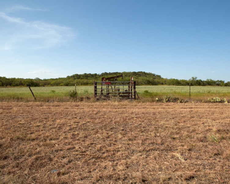
Arcola Drilling and Exploration, Inc. is a domestic for-profit Corporation founded in 2010 and dissolved in 2013. This image made in Midland, Texas shows contractors erecting an exploratory oil drill.
archival ink jet print
20" x 25"
2012
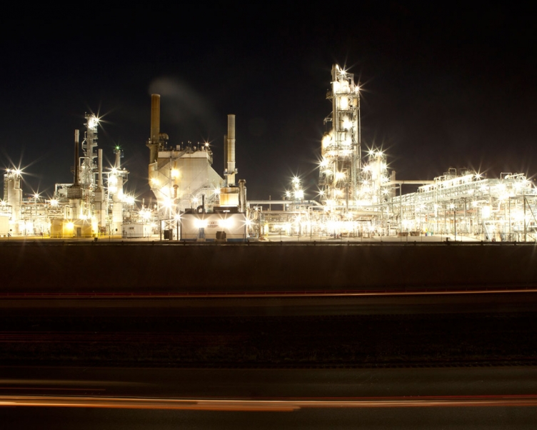
The Alon Big Spring Refinery is a sour crude cracking facility with an aggregate crude oil throughput capacity of approximately 73,000 barrels per day and a Nelson Complexity of 10.5. The Big Spring Refinery processes 100% Permian Basin crudes. The Big Spring Refinery has the capability of turning sweet and sour crude into highly refined products. Alon uses adjectives to describe some of its products such as "clean gasoline" and "ultra-low-sulfur diesel" - which Alon claims is a cleaner, more-efficient fuel that offers an immediate answer to the concerns about greenhouse gas production and global warming. Alon also produces petrochemical products and jet fuel.
archival ink jet print
20" x 25"
2012
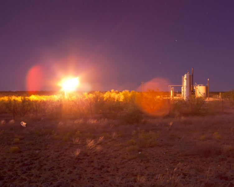
AggieTech is a privately owned company whose focus is on the Permian Basin of West Texas and Southeastern New Mexico. Mission Statement: "Big Bear Aggietech exists to provide a distinctive service to the oil and gas industry. Through honesty, integrity, and sincerity we are building a company in which our employees, customers and community can all take pride." When petroleum crude oil is extracted and produced from onshore or offshore oil wells, raw natural gas associated with the oil is produced to the surface as well. Especially in areas of the world lacking pipelines and other gas transportation infrastructure, vast amounts of such associated gas are commonly flared (burned off) as waste or unusable gas. The flaring of associated gas may occur at the top of a vertical flare stack or it may occur in a ground-level flare in an earthen pit as in the photo above. All of West Texas smells horrible - like burning oil and gas.
archival ink jet print
20" x 25"
2012
archival ink jet print
20" x 25"
2012
In the distance, farm hands are using a wheat thresher to separate the grain from stalks and husks. For thousands of years, grain was separated by hand with flails, and was very laborious and time consuming, taking about one-quarter of agricultural labor by the 18th century. Mechanization of this process took much of the drudgery out of farm labor. While making this image one of the farm hands drove over to my car to see if I needed help and asked me about my project.
archival ink jet print
20" x 25"
2012
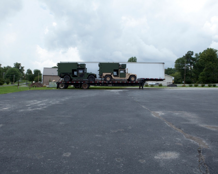
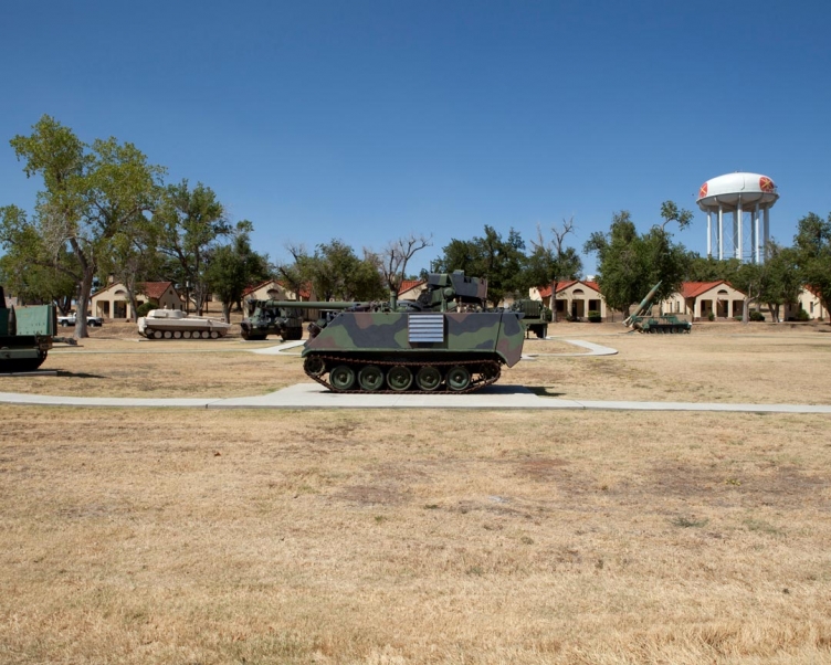
The US Army Field Artillery & Fort Sill Museum was established in 1934 and formally opened in 1935 with the mission of preserving the history of both the Field Artillery and of Fort Sill. In 1998 a new initiative known as Project Millennium established new objectives for the museum and included the construction of a separate US Army Field Artillery Museum, which was completed in the spring of 2008. As the new Field Artillery Museum neared completion, plans were developed to separate the mission of the museum into two distinct missions (Field Artillery and Fort Sill). Today, the Fort Sill National Historic Landmark and Museum occupies 38 buildings, with a total of 144,514 square feet of exhibit and storage space, a total collection of over 235,000 objects, and covering 142 acres in the Historic Landmark area.
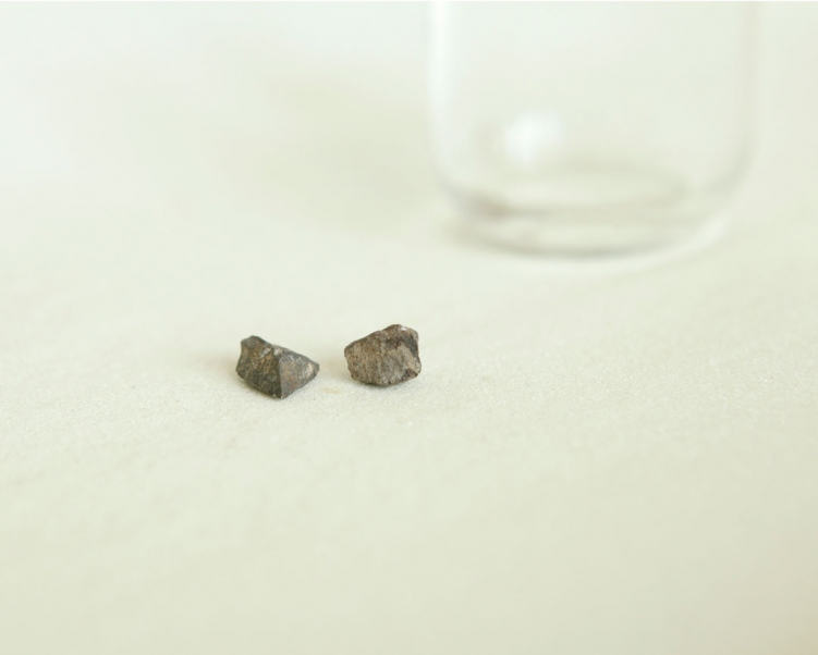
found object
2012
My summer travels were mostly without incident, however while driving through Channahon, Illinois on my way to Chicago a truck threw this rock into my car window which ricocheted and hit me in the head. Shortly after, a truck in front of me had a tire blow out and almost hit my car.
archival ink jet print
20" x 25"
2012
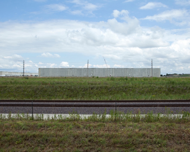
This newly designed Stocking Distribution Center in Joliet is 1.6 million square foot. It will employ approximately 200 people and serve more than 340 Home Depot stores across the Midwest.
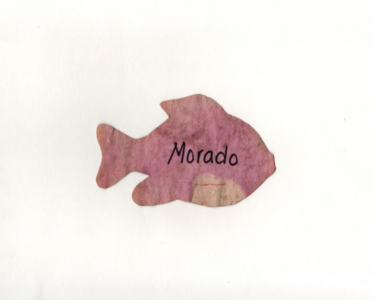
found object
2012
This fish named Morado was found while camping at White Oak near Starved Rock State Park.
archival ink jet print
20" x 25"
2012
video
2012